Fun Free Tools for Map Geeks
In personal terms, the adage “compare and despair” makes a lot of sense – happiness is at least partly relative, and as long as you compare yourself to the Joneses, you’ll be trying to keep up, not enjoying what you have.
But in the spatial realm of architecture, cities and planning, comparison is extremely helpful and even necessary. How can we avoid making the same mistakes other cities have made if we’re not aware of what others have done? Measurable, scalable physical comparisons are key. Of course, size isn't everything, but it's a fascinating comparison to see one place laid atop another.
A new online computer tool makes physical mapping comparisons a lot easier than they’ve ever been. You don’t need special software or GIS training, just the link to the MapFrappe website and a decent computer to play around on. Henry Grabar in Atlantic Cities online alerts us to this free mapping tool.
The tool is especially cool because:
- It can be used at whatever scale you want
- You can travel to whatever part of the world Google has bothered to digitally document
- North is always north
- The interface is so smooth that navigating the maps is a pleasure (at least on the desktop computer we used in our test)
- You can see aerial satellite views, or overlay the terrain onto the map view
- You can save and share comparisons (see below)
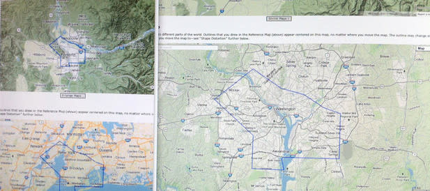
How it works: outline whatever area you want to use as a comparison – I did a quick and dirty outline of Portland city boundaries, for instance. That base map magically appears right in the middle of a second, comparison map on the lower half of your screen, showing the entire United States (in the case of Portland, it's a tiny blue dot). You scale up or down with the slider on the left side of the screen, just as you would on a typical Google Map application. The whole time, your base map outline – Portland's city boundaries – stays in the center of the map. You can move the map so that Portland appears anywhere in the world.
Save and Share: When you make an comparison you want to keep, simply click the button that says "Make URL" and it'll save the URL as a live link. I compared the South Park Blocks to the National Mall in Washington, DC. It turns out the green space of the South Park Blocks – where our farmers market spreads out, for instance – is barely bigger than the Reflecting Pool of the Mall alone. Our capital city is indeed built at a grander scale than Stumptown is.
Play around on the site and answer the questions you’ve always wondered about, like:
- How do Portland and Brooklyn (NY) really stack up against each other?
- Is Portland a small city, physically, or is it just easy to get around, so it feels that way?
- Are Austin’s city streets really as gigantically wide as they feel? What about Lake Oswego's?
Compare great spaces of the great cities: Central Park, Portland’s Park Blocks, the Champs Elysees, the Ramblas in Barcelona – whichever are your favorites, or wherever you've always wanted to go.
The list of examples on the website is interesting too, and shows us some match-ups we may have wondered about, like Texas vs. France (I’d love to see those two teams suited up against each other), and some we may not but that sound intriguing: Devils Tower vs. White House, Golden Gate Bridge vs. Brooklyn, and the Washington Mall vs. the Tuileries in Paris.
Of course, I couldn't resist comparing Portland and Brooklyn (NY), also. And Portland and Paris!
The site is copyrighted by Kelvin Thompson, who wisely notes: “This page may not be accurate. Don’t depend on it for anything important.” But it’s certainly a fun tool for map geeks – and there must be a lot of us in Portland; why else would that sticker of the map of Oregon with the heart logo be seen on every car and bike in town?


