Plotting Portland's New Skyline
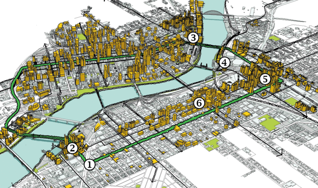
*Led by chief planner Joe Zehnder, Portland’s Bureau of Planning and Sustainability created this diagram for its Central City 2035 effort to envision a “Center of Innovation and Exchange.” The vision is still in progress. To find out more, go to portlandoregon.gov/bps.
As they look to Portland’s future, urban planners see the city of someday: in this case, 2035. The orange buildings on this map are all imaginary—for now. They represent what could be built, according to current zoning, on central-city lots now occupied by little buildings likely to be torn down one day. (Existing buildings listed on the National Historic Register live on in this forecast.) The other stuff? Hoped-for future projects that—as with all of Portland’s plans—might be wishful thinking, or not.*
1 Over the decades, urban planners have hatched many bold visions: waterfront parks, public squares, civic centers, streetcar lines. Here, they foresee the still-unnamed pedestrian/bike/transit-only bridge opening in 2015 as part of a pedestrian/bicycle loop connecting every district of the central city.
2 Connected by light rail, streetcar, aerial tram, and the new bridge, the southern reaches of both sides of the Willamette are poised to become an “innovation quadrant,” uniting Portland State University, Oregon Health & Science University, the Oregon Museum of Science and Industry, and Portland Community College. PSU’s plans call for 7.1 million square feet of new development, OHSU’s for 2 million on its 26-acre South Waterfront campus, while OMSI imagines 10 acres it owns around a new MAX stop as 2.4 million square feet of craft, tech, and creative spaces—plus a hotel and housing.
3 Farther north, as the last of the city’s former industrial railroad land becomes developed—with no height limits at all—the area known as the “North Pearl” is already becoming a bigger, bolder part of the city.
4 Just as famed planner Edward Bennett, in 1912, imagined a waterfront park where only docks existed on the Willamette River’s western shore, current planners envision the Rose Quarter one day stepping down to the banks—further connecting the city to the river at its heart.
5 With 70 acres of surface parking lots beckoning new buildings, the Lloyd District could evolve into a long-envisioned “second downtown” and “eco-district.” First moves are under way.
6 With numerous empty lots, former car dealerships, and other underutilized land (much of it owned by developer Joe Weston), E Burnside Street and NE Sandy Boulevard are poised to become major corridors of growth, the first glimpse of which will rise at the Burnside Bridgehead.
- A Bigger Portland is On Its Way—And Here's What It Will Look Like
- Plotting Portland's New Skyline
- North Pearl: Going Up?
- Lloyd District: Ecotopia
- The Jade District: East Side, Redefined
- Orenco Station: Westward Expansion
- Four Buildings That Are Setting New Design Standards in Portland
- Portland's Hottest Neighborhoods: Where to Buy Now
- Neighborhoods by the Numbers
Our annual guide to 120 neighborhoods and suburbs in a sortable table of comprehensive real estate data.