Crossing Guard
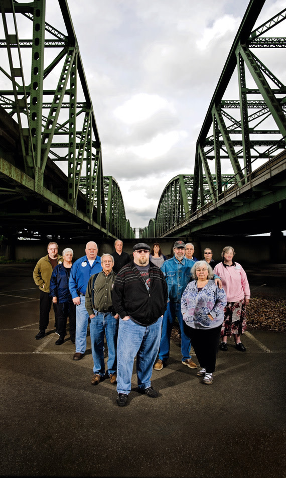
Members of HiNoon and the Hayden Island Livability Project in the Red Lion Hotel parking lot, beneath the northern end of the current I-5 bridge.
If the Columbia River Crossing were a raging river instead of a four-mile-long stretch of new roadway and interchanges designed to span a river, it would be easy to imagine the $2.6 billion-plus project smashing into the landscape with all the hyperbolic force of a Roland Emmerich disaster flick. Imagine:
Scene 1: Beginning around E 39th Street in Vancouver, the growing concrete tide flows southward innocently enough, sweeping away a few scattered houses like toothpicks.
Scene 2: Gaining momentum, it trims away part of Fort Vancouver and smashes through the corner of the Regal City Center 12 movie theater.
Scene 3: Plunging into Oregon, the deluge unleashes its full fury upon little Hayden Island in a wave of 22 freeway lanes and ramps nearly five city blocks wide.
So long, big chain restaurants like Newport Bay, Denny’s, Hooters, B.J.’s Restaurant & Brewhouse, and McDonald’s. Wave goodbye to mom-and-pop shops like Dotty’s, Paddy’s, Dede’s Deli, Pushing the Envelope, and Paul’s Trading Co. And here’s hoping the 30 houseboat dwellers in the Crossing’s path have scrambled to higher ground.
But, as in any good disaster film (and in certain ginormous transportation projects, too), there needs to be a hero, or at least someone to stand valiantly in the path of the bedlam. And last November, in the parking lot of a Hayden Island grocery store located directly in the Crossing’s floodplain, a small group of residents auditioned for the part, brandishing petitions and picket signs scrawled with the humblest of requests: “Save Our Safeway.”
The Jantzen Beach Safeway is the only place to buy groceries and prescription drugs on Hayden Island. In fact, it’s the only place within a five-mile drive or a half-hour bus ride. Most of the protesters who’d assembled in the store’s bustling parking lot that day live in the Hayden Island Manufactured Home Community, a verdant, vintage 1970s riverfront village of 440 single- and double-wide trailers. A sign at the village’s gateway advertises “Homes as low as $7,999.” Many of its residents are poor, old, physically challenged, or on fixed incomes—sometimes all of the above. According to protest organizer Erick Reddekopp, should the island’s Safeway close, even only for the year or two necessary to rebuild it someplace else on the island, many of the residents will have no choice but to move.
Dubbing themselves the “Hayden Island Livability Project,” Reddekopp and his fellow manufactured-home dwellers were beyond worried—they were angry. Demolishing the Safeway had been one early option in the Columbia River Crossing plan, but the islanders thought the planners had dropped that idea for good. Then, last year, the Crossing’s ballooning price tag forced major cuts to the project, and, poof, no more Safeway—without even a public hearing or an e-mail alert, much less a serious consideration of the consequences.
{page break}
“The Columbia River Crossing held 75 meetings on the island, but it was all Disneyland pictures of the paradise they are going to create,” Reddekopp says. “They never informed us the Safeway was going to be destroyed.”
The Hayden Island Livability Project joined a growing chorus of dissent that is stalling, if not threatening the life of, the Columbia River Crossing. In September, Mayor Sam Adams abruptly turned rank, yanking his original support for a 12-lane bridge in favor of a smaller design; Metro Council President David Bragdon began calling for a more comprehensive reconsideration of the size and scope of the entire project. In January, Adams and Bragdon joined with Vancouver Mayor Tim Leavitt and Clark County Commission Chair Steve Stuart in a letter of protest to Washington Governor Christine Gregoire and Oregon Governor Ted Kulongoski. The “cost, physical and environmental elements of the project as currently proposed impose unacceptable impacts on our communities,” they wrote. Requesting a “stronger voice for our local governments,” they argued for better management, a more realistic financing plan, and money to hire their own consultants to appraise key features of the project. Plus, in a big nod to the angry voices from the trailer park, they asked the governors to “commit to meeting the needs of the Hayden Island Community.”
Gregoire and Kulongoski shot back, extolling the project’s benefits: alleviating congestion, improving safety, and easing the movement of West Coast freight. Instead of bowing to local wisdom, they vowed to appoint their own independent committee of “national experts” to review the project. They also drew a not-so-subtle line in the sand: “The citizens of this region have watched our two states discuss and plan for a new bridge for over 20 years … they expect us to proceed.”
Bragdon and other bridge watchdogs were furious. “The governors appointed this stooge committee with a limited scope of work,” Bragdon said after discovering that the committee would be weighted with engineers, transportation officials, and a contractor. “They’ll fly them in, and they’ll issue their report: ‘Oh, this is great, go ahead.’”
Only weeks after the governors’ letter, the Architecture Foundation of Oregon happened to bring its own panel of nationally credentialed urban thinkers to review the project. The group—which included Pulitzer Prize–winning architecture critic Robert Campbell; one of the Columbia River’s leading historians, Richard White; and the former director of the National Endowment for the Arts (NEA) design program, Maurice Cox—skewered the project as a threat to the region’s livability and for its failure to uphold Portland’s reputation as a transportation innovator.
“Portland is where people go to see the most progressive thoughts on contemporary planning and transportation in the country,” Cox said, summarizing the group’s conclusions. “I’ve brought delegations of elected leaders from other cities to ride your systems. But I look at [the plans for the Columbia River Crossing] and ask, ‘How did this happen?’”
{page break}
POLITICAL TREMORS DURING THE FINAL PLANNING stages of any urban transportation project of this scale are hardly rare. But the political schism at the heart of the Columbia River Crossing is wide and deep, and nowhere is it more vividly displayed than in the debate over Hayden Island. Fundamentally, it’s a debate between state and local government over whom transportation projects should serve: the people driving on the roads, or the people living around them.
Effectively a 1,400-acre sandbar jackknifed into the Columbia River, Hayden Island has long been shaped primarily by the needs and desires of those on the roads. In 1928, as Highway 99 swelled with traffic between Seattle and Portland, the island sprouted one of the nation’s largest amusement parks, complete with four swimming pools, a dance pavilion for 2,500, and the Big Dipper, the “biggest roller coaster west of Chicago.” By the 1970s, the park was gradually supplanted by the Jantzen Beach SuperCenter, a mall that, over the past two decades, has bloated into an 80-acre collection of big-box stores fed by Washingtonians seeking to evade their state’s 8.2 percent retail sales tax. Adding to the attraction are Oregon’s lower cigarette taxes (84 cents less per pack) and more abundant video poker and lottery games. State-sponsored gaming in the 97217 zip code that encompasses the island came to $37 million last year, nearly twice that of Gresham, the closest competitor. Meanwhile, the Stateline Liquor Store rang up more sales than any other OLCC store in Oregon.
‘The citizens of this region have watched our two states discuss and plan for a new bridge for over 20 years … they expect us to proceed.’
—Governors Christine Gregoire and Ted Kulongoski
Yet surrounding the carnival of bars, restaurants, and chain stores bracketing i-5 are the 2,155 people who call Hayden Island home. To the east lies a quiet community of high-end waterfront condos and houses, floating homes, and yacht berths—its residents often sport the casual, ships-ahoy fashions to match. But along the northern shore is the equally picturesque, if more modest, Hayden Island Manufactured Home Community. Arguably the region’s most affordable waterfront living, the homes, mostly decades old, are flanked by well-tended gardens, mature trees, and jaunty ’70s-era carports. Many owners get around using walkers and electric scooters. All in all, the place has the ambience of a retirement community crossed with a scenic campground.
Having long lived with i-5 zooming through the island, the residents weren’t too concerned about a bigger freeway, at least at first, says Roger Staver, chairperson of the island’s neighborhood association, HiNoon. Their sensitivities were more attuned to issues like new condos poking through the island’s 45-foot height limit. But when developers proposed building a new Wal-Mart in their backyard in 2006, the islanders flexed their muscles for the first time. Sam Adams, then city commissioner, rushed to the rescue, slapping a moratorium on all new construction on Hayden Island, and the Portland Bureau of Planning began working with both the residents and the managers of the Jantzen Beach SuperCenter to craft a future vision for the island. As their planning commenced, the Crossing seemed like an opportunity: the arrival of the new, wider freeway would bring a light-rail line linking Hayden Island to Portland and Vancouver. And so, together, the islanders and the planners conceived the Hayden Island Plan, the community’s first blueprint for the future. At the center they envisioned a completely new future SuperCenter: an urban village with streets, à la Bridgeport Village, with both national retailers and an intimate neighborhood district of shops and new housing adjacent to the coming light-rail station.
{page break}
Residents understood that the Crossing’s freeway would be large, but it was also supposed to ride on columns high above the island. “I went to the various open houses they had,” recalls Tom Dana, one of the Livability Project’s early organizers. “I knew it was 22 lanes, but it just didn’t register with me how big that was. I just took their word that it would be OK.”
The Crossing’s planners can explain the “why” of every ribbon of concrete, whether it’s to keep the weekend crushes of mall shoppers from backing up onto i-5 or to give 18-wheelers exiting nearby NE Marine Drive (the busiest freight conduit in the region) enough road to reach 55 miles per hour before merging onto the freeway. But even those designing the new freeway variously describe the Hayden Island section of the bridge as “an aircraft carrier” and a “plate of fettuccini.” For a sense of scale, stand by the Starbucks in Pioneer Courthouse Square, look south to the Portland Center for the Performing Arts, and imagine those 950 feet of SW Broadway transformed into freeway lanes and ramps.
When the Crossing’s first cost estimates arrived in March 2009—a breathtaking $3.1 to $4.2 billion—elected leaders experienced sticker shock. Key funding gatekeepers, led by Oregon Congressman Peter DeFazio, began calling for major cuts. The Crossing’s planners quickly responded by trimming $650 million worth of lanes and interchanges from the project. But the $125 million chopped out of Hayden Island’s section came out of the freeway’s height. And so, in early November, the islanders suddenly discovered that their flyover freeway had plunged to the ground and plowed right through their only grocery store.
According to Victor Viets, a HiNoon member and a retired civil engineer, that’s when residents of the island first began to comprehend the project’s ramifications. “It’s hard for regular citizens to get a whole lot out of a set of drawings,” he says. “But when they took the Safeway, and people realized most of our restaurants were going, too, it finally hit home.”
Crossing planners like Steven Witter point to their efforts to work with the islanders to improve the design. For instance, the planners shrunk a proposed ring road around the SuperCenter from five lanes (the width of SE Powell Boulevard) to a more neighborly three lanes. The new, lowered freeway had forced the island’s “Main Street,” N Tomahawk Island Drive, into a tunnel 25 feet deep. The Crossing’s planners raised the tube by 8 feet and, at the islanders’ request, proposed ideas like festooning the dark, potentially scary 500-foot-long underpass with a public-art lighting display.
Earnest as such efforts were, islanders concluded that they were “just trimming the toenails of the elephant.” But as the residents pondered the full impacts of the freeway’s new design, they also discovered that the Hayden Island Plan, despite being a long-range vision, had given them something more immediately useful: a sense of unity.
“We had something to point to—that these are our goals for the island,” says Roger Staver, the HiNoon board chair. “It was like forming an army. We had our weapons ready. All we needed was to be attacked.”
{page break}
OPINIONS VARY ABOUT HOW MUCH THE Crossing’s proposed 22-lane section on Hayden Island can be shrunk, never mind how quickly the various other disagreements over the project (tolling and aesthetics being the biggest) can be resolved. Packed with high-ranking, transportation-savvy Democrats, the Northwest’s federal delegation is positioned, as governors Gregoire and Kulongoski pointedly wrote in their letter, “to leverage substantial federal resources” for the project in next year’s omnibus transportation bill. Currently, $400 million is penciled in for the Crossing. But the region’s congressional delegation is unanimous on one point: for the project to be included in the bill, state and local governments must reach a consensus about the Crossing’s size and design.
Metro Council President Bragdon, currently serving his final few months due to term limits, takes a longer, more philosophical view of the Crossing’s prospects. Congress, he shrugs, can always put a “placeholder” for the money in the bill while the locals battle things out. But even with federal funding, Bragdon remains skeptical that the Oregon Legislature will find its share of the Crossing’s price tag—$400 million—in the face of the anticipated $2.4-billion-plus budget shortfall in the next biennium. For it to be built at all, Bragdon argues, the Crossing needs to be significantly rethought.
‘You can’t just oppose the freeway. YOU HAVE TO ACTUALLY STAND FOR SOMETHING, to show an alternative vision.’
—Maurice Cox, National Endowment for the Arts
To that end, Maurice Cox from the NEA offered some advice during his Portland visit in March. As the city councilman and, later, mayor of Charlottesville, Virginia, in the early 2000s, Cox successfully campaigned to shrink the size of a planned freeway through the city’s center. A key weapon, he recalls, was an alternative design. “You can’t just oppose the freeway,” he said. “You have to actually stand for something, to show an alternative vision.”
Everyone from Adams and Bragdon to islanders like Victor Viets, the retired civil engineer, took Cox’s words as a new battle cry. Adams hired his own consultants to explore removing some of Hayden Island’s ramps in favor of sending the local traffic back from the Oregon mainland over one or two smaller bridges to the south. Both Viets and Metro’s chief planner, Andy Cotugno, began working on schemes to reshape the lanes in order to minimize the path’s impact. Meantime, Bragdon is swinging for the fences: he plans to run all of the original traffic, population, and economic projections through Metro’s own powerful computer modeling program, MetroScope, in hopes of building his argument that the region’s goals can be better met with a smaller Crossing.
One of the most powerful figures in the Crossing’s hierarchy has also jumped into the fray: Henry Hewitt, a lawyer who, for six years, has co-chaired the bi-state task force overseeing the project. At his demand, Crossing planners are now working directly with Metro and the City of Portland on all of their efforts. “For the first time,” Hewitt says of the simmering tensions between the state and city governments, “I think we’re making progress.”
{page break}
Ominously, though, all of those efforts will have to be rushed—if they can be completed at all—to be meaningfully reviewed by the governors’ independent review panel. Its chairperson, Thomas Warne, the former executive director of the Utah Department of Transportation, promises that the committee will look at “anything that is available.” But when asked about all the new local initiatives, his voice grows tight: “We have a timeline to meet.” He must file the final report to the governors by July 30.
Meantime, the Hayden Island Livability Project is taking no chances: the group has initiated what is, more or less, its own independent review of the Crossing.
Working with Willamette University College of Law’s Sustainability Law Clinic, the islanders convinced Oregon’s Environmental Justice Task Force (a watchdog body that Governor Kulongoski himself signed into being in 2007) to review the Crossing’s impacts on their community. On April 19, the task force sent the governor a letter describing “systemic problems” ranging from how the Crossing’s planners determined the island’s demographics (using 10-year-old census information) to the lack of citizen involvement in the decision to demolish the Safeway.
As Sustainability Law Clinic director and task force member Jonathan Ostar explains, the U.S. Environmental Proctection Agency (EPA) sets strict guidelines for how “environmental justice communities”—that is, low income or racially diverse neighborhoods—must be handled. “With big transportation projects, the involvement of low-income communities is often tokenized,” Ostar says. “They just want to check the box. The EPA requires that these communities have meaningful involvement—that they not only be heard, but that they be allowed to influence.”
Like others in the Hayden Island Livability Project, Erick Reddekopp has never played the part of activist before. A computer consultant, he moved to the island two years ago to be closer to his aging parents. “My father discovered the island during his last stint for the Postal Service delivering mail here,” Reddekopp says. “Over time, I’ve fallen in love with it, too.”
The Crossing’s scale overwhelmed people, he says. The islanders either thought the project was too big to ever happen or resigned themselves to not being able to affect it. But their outrage over losing their grocery store turned into a petition drive that, in turn, led their local elected officials to demand that the two governors “commit to meeting the needs of the Hayden Island Community.” Now, Reddekopp and his fellow islanders believe they may be turning the tide of the Columbia River Crossing.
“We’re just at the beginning,” he says. “Not all the work the Crossing’s staff has done is bad. But let’s step back and start working with the communities to find a Portland solution.”