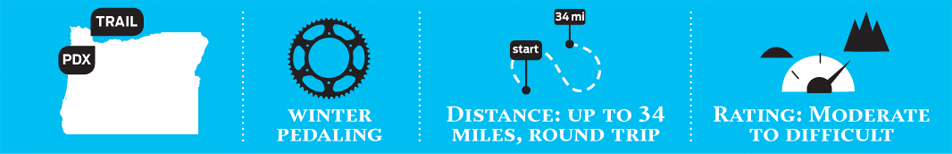
Crown Zellerbach Trail
WHY IT’S GREAT
Built on the remains of an abandoned logging road and railway line near Scappoose, this little-known hiker-biker path provides a ready outlet for mountain bikers and cross-racers who crave a car-free winter leg-burner. Spanning 17 miles, the trip’s scenery ranges from the placid, bird-rich banks of Multnomah Channel (a Columbia River backwater) to the wild and woolly outer reaches of the Coast Range. Trail surfaces oscillate from paved asphalt to grass and dirt, rutted gravel roads, and short bursts of muddy singletrack. For a mellow 8-mile out-and-back, head east, toward downtown Scappoose, to reach the channel and vistas of snowbound Mounts Adams and St. Helens. Head northwest, tracing the Scappoose-Vernonia Highway and Scappoose Creek, where you’ll spot thick, second-growth fir forests, free-range cattle, horse corrals, rustic barns, and swooping hawks. (Note: at press time, a washout approximately four miles up the west side of the trail requires a chilly ford of Alder Creek. Exit the CZ Trail at Walker Road and pedal up the Scappoose-Vernonia Highway a short distance to Cater Road.)
DON’T FORGET
While the CZ Trail ends at Highway 47 in Pittsburg, those looking for a true winter epic can ride approximately 3 miles south, down 47, and link up with 21-mile Banks-Vernonia Trail.
POST-HIKE WATERING HOLE
Mark’s on the Channel On warmer days, take a seat on the wraparound deck of this floating restaurant set on glassy Multnomah Channel as the sun sinks past the boat masts with a Fort George IPA in hand. Try the oyster stew, filled with a sweet, creamy wine sauce, scallions, and bits of red onion. 34326 Johnson’s Landing Road, Slip I-3, Scappoose; 503-543-8765; marksonthechannel.com
TRAILHEAD DIRECTIONS
Follow Highway 30 to Scappoose (21 miles), and turn left on Scappoose-Vernonia Highway. Drive 1.8 miles, and look for the trailhead on the right. Head east on the trail to reach Chapman Landing, or turn northwest to venture into the wilderness. No fees or permits required.