Choose Your Own Adventure
(Plus, with today’s gas prices, who can afford it?) So we give you this: 18 ultimate outdoor escapes less than 90 minutes away. Consider it your guide to the perfect summer. Now what are you waiting for?
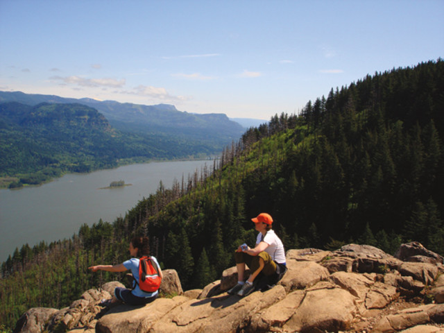
HIKE
PART OF HIKING’S APPEAL is its simplicity: You’ve only got to lace up your boots, grab a water bottle, and get out the door. But when you live within 90 minutes of more than 100 state parks, 8 wilderness areas, and the coast—not to mention our city’s own 189 parks—just picking a destination can be exhausting. So before you go cross-eyed Googling “Portland + hikes” or get swept up in an avalanche of guidebooks in the Rose Room at Powell’s Books, consider these tried-and-true outdoor rambles. From pounding waterfalls to secret escapes in Forest Park, the only legwork required for these treks happens on the trail. —Brian M. Barker
RIDGE TRAIL
FOREST PARK. That Frederick Law Olmsted-inspired, 5,100-acre stretch of evergreen hills double-dipped in moss, sword ferns, trees—and mud—that seems to make up the very (green) heart of our city. But when your own personal stomping grounds have been overexposed by the likes of the New York Times, is it even worth exploring anymore? You bet your Chacos it is. Consider the Ridge Trail: Located on the northeast side of the park, this short route tests hikers’ quads with a 1,000-foot vertical gain to one of Forest Park’s highest spots, where it links up with popular options like the Wildwood Trail. Perhaps because it was just completed in 2003, few people seem to know the route exists, which means you’ll probably have it all to yourself. And the view of the St. Johns Bridge from near the trail’s start alone makes this a worthwhile outing. Framed by big leaf maples, red alders, and flowering ninebark shrubs, the architectural treasure’s 400-foot-tall spires practically glow in the afternoon sun—a sight so moving, it could inspire a renewed love affair with this grand ol’ park. Or, hell, the whole city. —BMB
- Get there: Take U.S. 30 West and turn left onto NW Bridge Ave, toward the St. Johns Bridge. Find the small pullout immediately on the left side of the road. The trailhead is a short walk north on the road.
- Maps: www.forestparkconservancy.org
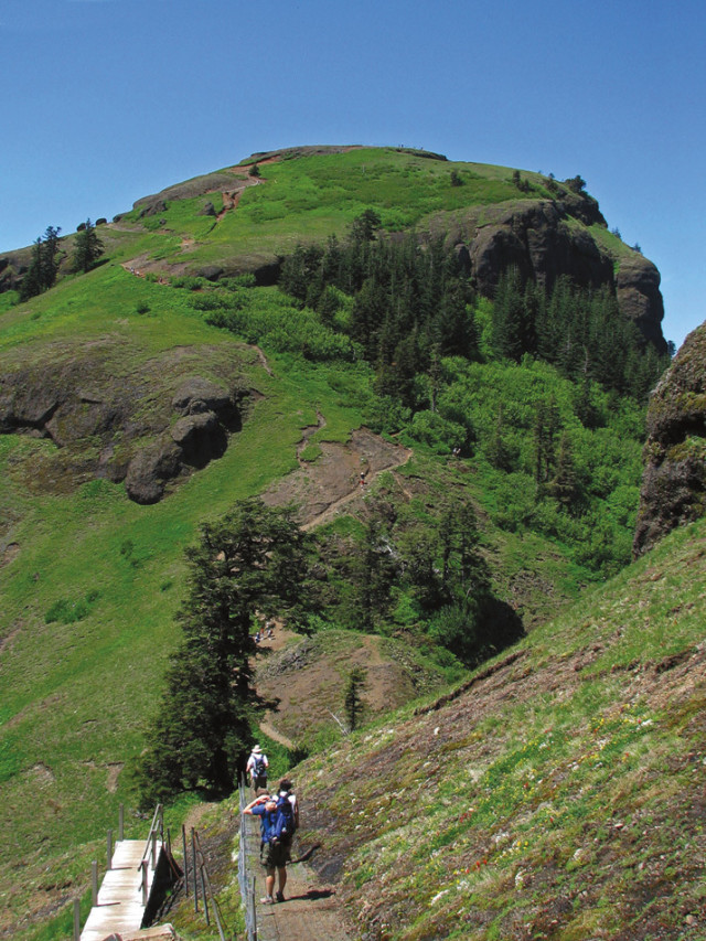
GOING UP? Yes, it’s steep. But the view from Saddle Mountain’s summit in the Coast Range is well worth the burn.
Image: Adam Schneider
SADDLE MOUNTAIN
AT 3,283 FEET, Saddle Mountain is the tallest peak in Oregon’s northwest corner, a topographic siren in the Coast Range that lures peak-baggers from miles away. And who can blame them? The wind-whipped summit would be a prime place to shoot one of those eye-popping IMAX films, what with its front-row view of five Cascade volcanoes, including Mounts Rainier and Jefferson, and the endless blue Pacific. Accessing such film-worthy vistas, though, doesn’t come easy. Hikers must endure a relentless climb through a forest thick with firs and white-barked alders to a precipitous series of crumbling switchbacks before arriving at the mountain’s bald crown. Until 1966, a fire lookout tower once stood here, but it couldn’t prevent four of the most intense fires in U.S. history—collectively called the Tillamook Burn—as they raged across the landscape between 1933 and 1951. Those infernos did, however, prompt one of the world’s largest reforestation projects: In 1949, Oregonians planted some 72 million seedlings in what eventually became the Tillamook State Forest. Today Saddle Mountain presides over this second-growth forest, while its mossy flanks are a sanctuary for endangered wildflowers like frigid shooting star and Saddle Mountain bittercress, which continue to thrive with a tenacity rivaling that of any trekker aiming to reach the rocky top. —BMB
- Get there: Take U.S. 26 west for 64 miles and look for the Saddle Mountain State Park sign. Turn right and drive 7 miles to the trailhead.
- Maps: www.nwhiker.com
ELK MEADOWS
IF RENOWNED YOGI Rodney Yee decided to ditch the tropical beach backdrops that adorn the covers of his best-selling yoga DVDs and unfurl his mat amid some Pacific Northwest splendor instead, he could do a lot worse than Elk Meadows. Tucked up against the 5,600-foot-high Bluegrass Ridge, this half-mile-wide span of blooming bear grass is one of Mount Hood’s finest sights. In snowy years, like this one, you might not get your boots on this trail until late July, but it’s worth the wait. The path winds past tart huckleberries and bright red thimbleberries before delivering hikers to Newton Creek, whose chilly waters must be forded to reach Elk Meadows. Note that such an endeavor is best undertaken in the wee morning hours, when the creek levels are at their lowest. Just as well. An early start ensures that, even without your yoga mat, you’ll have plenty of time for quiet reflection. —BMB
- Get there: From Hood River, take Hwy 35 South for 7 miles and turn right at the sign for the Mt Hood Meadows Nordic Center. The trailhead is 0.5 mile down the road on the right.
- Maps: Green Trails Map No. 462
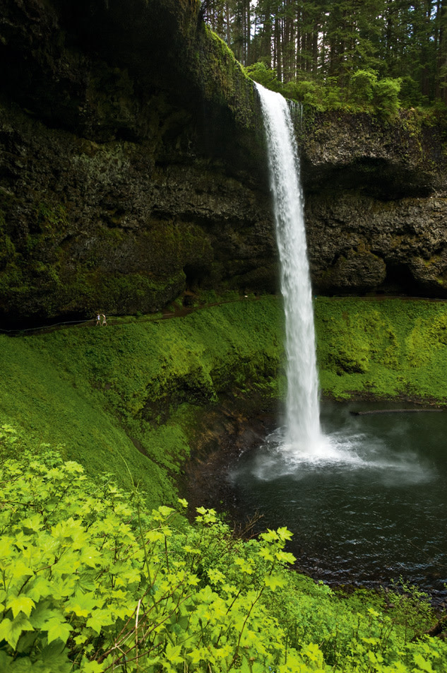
HYDRO POWER Feel the force of South Falls in Silver Falls State Park on a walk behind the 177-foot cascade.
Image: Mark Gamba
SILVER FALLS STATE PARK
TRUE, MORE THAN 25 cascades plunge from the Columbia River Gorge’s walls. But nowhere in that great, state-dividing rift can you reach as many in a single seven-mile bound—at least not without working up a serious lather—as you can at Silver Falls. Here, amid 9,000 acres of second-growth forest, 10 silvery giants plummet earthward. If you opt to visit all of them (which can take up to three hours, depending on your pace), begin at the South Falls Trailhead, where the surge of Silver Creek welcomes you to Oregon’s most-visited state park. The trail follows the creek as it cuts through a canyon of mossy rock, delivering you to gape-inducing sights like the Middle North Falls, a 106-foot sheet of thundering white water so powerful you’ll feel its breeze and its spray from several hundred feet away. By taking a dirt footpath off the main trail, you can view the glittering fury from a cave directly behind it—just be prepared to get wet. For a gentler sight, stop by the park’s tallest cascade, Double Falls, where a slender stream tumbles 178 feet into a shallow pool. It’s a grand spot to pull up a rock, unpack your picnic, and revel in the refreshing mist. —Martha Calhoon
- Get there: Follow I-5 south to hwy 214. Go east for 12 miles to the entrance of the park.
- Maps: www.silverfallspark.org
INDIAN HEAVEN WILDERNESS
OK, SO WE FIBBED. This one’s a little more than 90 minutes away. But considering that you’d need a week to explore the more than 80 miles of interconnected trails that crisscross Indian Heaven Wilderness’s 20,960 acres in the Gifford Pinchot National Forest, we figured the extra 30 minutes were worth it. You can start at the Thomas Lake trailhead, but the East Crater Trail is less trafficked. Some paths wend through lichen-draped hemlock and fir or subalpine meadows in early summer. Others climb steep volcanic formations like East Crater, Lemei Rock (the highest point in the area at 5,927 feet), and Lake Sahalee Tyee. But they all pass by water, like Blue Lake, backed by the cliffs of Gifford Peak; or swimmable Thomas Lake, near Falls Creek Horse Camp. In fact, the wilderness area boasts more than 150 lakes where hikers can set up camp, catch dinner, or simply bathe trail-weary toes in the clear, cold water—a kind of pedicure au naturel that will prepare you for the next day’s trek. —Camas Davis
- Get there: Follow Washington’s Hwy 14 East and take a left at the Carson turnoff. Take your first right after the bridge (this becomes FR 65). Go 12 miles to FR 60 and turn right. After two miles turn left onto FR 6035. The East Crater trailhead is 3 miles up the road.
- Maps: U.S. Forest Service Mount Adams Wilderness, Indian Heaven Wilderness, and Trapper Creek Wilderness Map
PRIME PERCH See eye-to-eye with eagles at Angels Rest, a classic Columbia River Gorge hike.
Image: Scott Weber,Michael Novak
ANGELS REST
YES, THE PARKING LOT at this stellar Gorge trail is often brimming with Subaru Outbacks jockeying for an open spot, but it’s a far cry from the outright circus three miles up the road at Multnomah Falls. More important, though, Angels Rest is a tonic for the time-pressed outdoorsman: Nowhere else can such a mesmerizing view of the Gorge be had within a half-hour’s drive of Portland. Along the 2.3-mile trip to the top, day hikers can pause to peer at 175-foot Coopey Falls before billy-goating across a rock slide and scrambling to reach the summit, a bare expanse of earth 1,500 feet above the Columbia River. From your perch, you can just make out the tip of Mount Adams puncturing the sky, hold court with soaring golden eagles, and feel invigorated by a heart-pumping hike that’s just a quick jaunt from your neighborhood brewpub back home. —BMB
- Get there: Travel east on I-84 for 25 miles and take Exit 28 toward Bridal Veil. Continue for 0.25 mile and look for the large parking lot on the right side of the road.
- Maps: www.fs.fed.us/r6/columbia/maps
EAST ZIGZAG MOUNTAIN AND BURNT LAKE
THERE’S NOTHING WORSE than humping a heavy load all day only to set up camp in the middle of a plain old forest. When you commit to a long haul, you want to end your day on the shores of a rushing river or a crystalline lake, like, say, the four striking acres of deep blue that make up Burnt Lake in Mt Hood National Forest. You could take the short route to Burnt Lake (a mere four-mile hike from the Burnt Lake North trailhead), but traveling the road less traveled will make that inaugural dip in the spring-fed oasis all the more pleasurable. Just remember to start early to secure one of the seven primitive camping spots at the lake. The hike begins on Zigzag Mountain Trail and wanders through a meadow filled with lush pink rhododendrons and sweet huckleberries. As you climb northeast toward the ridge of 4,971-foot East Zigzag Mountain, stands of mountain hemlock and lodgepole pine keep watch over a rich understory of tiger lily, bear grass, and goldenrod flowers. Savor the landscape and the relatively easy hiking while you can, because as soon as you reach the junction with Cast Lake Trail, you’ll have to tackle a steep half-mile-long section to the top of East Zigzag. To the east, a soul-stirring 180-degree view of towering Mount Hood is your reward. That and sparkling Burnt Lake, beckoning from 800 feet below—a mere 1.1 miles farther along the trail. —CD
- Get there: Take U.S. 26 East toward Mount Hood. At 4.6 miles past Sandy, turn left on East Lolo Pass Rd and follow it to East Mountain Dr. Turn right. The road dead-ends at the trailhead 0.5 mile ahead.
- Maps: Green Trails Map No. 461
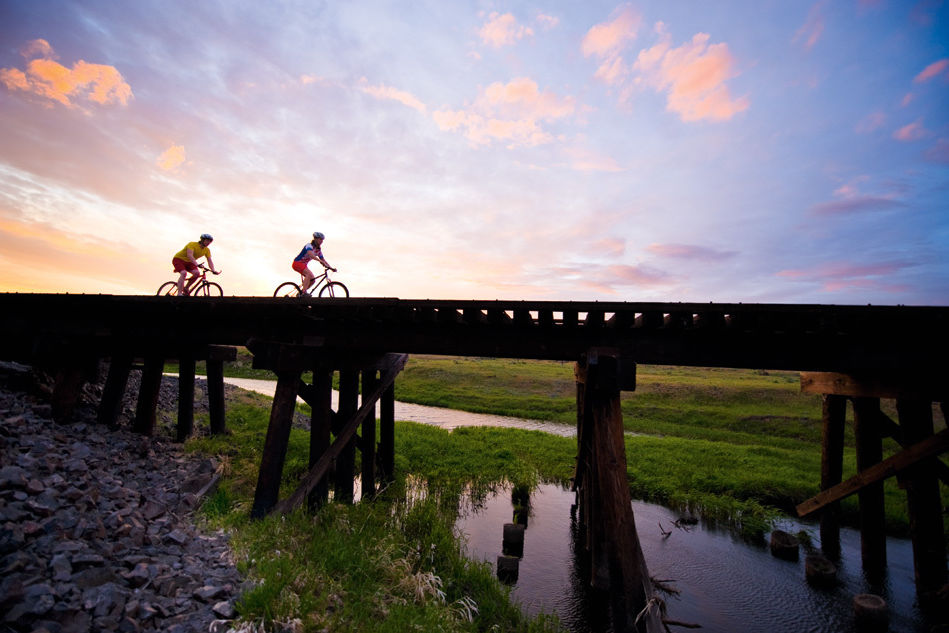
BIKE
GIVEN OUR CITY’S STATUS as the country’s golden child of cycling, we were a little nervous about naming four ultimate biking adventures. After all, 6 percent of Portlanders consider biking their primary mode of transport. But even if you know the fastest route from OMSI to Big Pink, you may not know where to lay fat tire to trail, or where to take your niece for that first training-wheel-free pedal (besides the school parking lot). No worries: When you’re ready to shift gears from commuting to communing with nature, try one of these rides, where success isn’t measured by speed, but rather the size of your smile. —Stacey Wilson
WILD RIDE Fat tires meet a field of flowers on the Klickitat Trail in the Columbia River Gorge.
Image: The Mud Blog
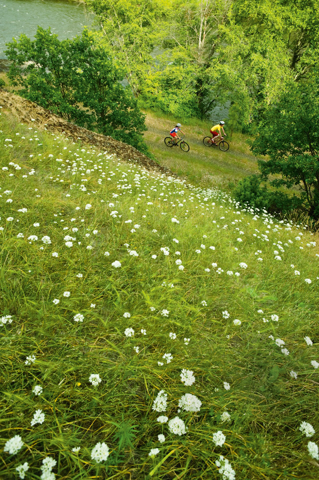
KLICKITAT TRAIL
SPANNING THE GRAVELLY corridor between the tiny towns of Lyle and Warwick, Washington, this newish addition to the Columbia River Gorge has a complicated backstory with as many turns as the trail itself. After the Burlington Northern Railroad ceased operations here in the early 1990s, national conservancy group Rails-to-Trails purchased the 31-mile stretch of abandoned track from the state for $3.1 million, stripped away all the rails, and transformed it into a mountain biker’s playground—a process that took more than 10 years, owing to ongoing battles over land rights with local landowners. Since it opened in 2003, the gentle ride through prairieland has quickly become a favorite of locals and Portlanders alike. The route kicks off near Lyle and follows the Klickitat River for about 16 miles along a slightly rugged and bumpy trail. If you’re lucky, you’ll spy fishermen from the Yakama Nation’s Klickitat tribe dip-net fishing for chinook and coho salmon at Lyle Falls, just two miles from the trailhead. Where the trail departs from the river, the landscape begins to fade from the familiar fir-flecked Gorge scenery to the sparse grass hills surrounding Swale Canyon. While it’s sometimes closed in summer because of fire danger, this stunning stretch of sunburned land offers 12 miles’ worth of reasons to make a return trip in the fall. —SW
- Get there: Take the Hood River Bridge to Washington’s Hwy 14 and go east for almost 11 miles. You will see the trailhead on your left.
- Maps: www.klickitat-trail.org
SAUVIE ISLAND LOOP
BETWEEN THE working farms, flocks of sandhill cranes, and views of our local peaks, this ride through an agrarian paradise is practically a Portland rite of passage. Even dyed-in-the-spandex fanatics (who, let’s face it, don’t normally gush about flat, amateur-friendly road routes) tout it as the most gorgeous stretch of earth on which to lay rubber to road—besides the revered Digne-les-Bains near the French Alps. And with good reason. Along the smooth, two-lane surfaces of NW Gillihan and Reeder Roads, you’ll see pumpkin patches, U-pick peach orchards, and even a vineyard owned by rock groupie Pennie Lane. As lovely as the island’s bucolic terrestrial offerings may be, even more wild beauty dwells in the skies. With over 250 species of birds inhabiting the island, spellbinding avian formations are common sights. Just be sure to look down when winding up your ride along the Multnomah Channel: Sauvie’s waddling mascot, the wood duck, has been known to cross the road now and then. —SW
- Get there: Take U.S. 30 West to Sauvie Island. Follow NW Sauvie Island Rd as it curves left after you cross the bridge, and park in the gravel lot next to the Cracker Barrel store.
- Maps: www.sauvieisland.org
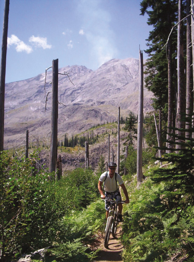
BLOWN AWAY Get an up-close look at Mount St Helens’s blast zone on the Ape Canyon Trail.
Image: Mark Gamba
APE CANYON TO PLAINS OF ABRAHAM
GIVEN THIS RIDE’S razor-sharp ridges, slapping winds, and the lingering late-season snow, even experienced mountain bikers who attempt the strenuous route have sometimes wondered, Man, is this really worth it? The answer, of course, is yes, and the proof comes at about mile 10, where you’ll get a so-close-you-can-almost-smell-the-lava view of Mount St. Helens’s north flank. But you’ve got to earn it first. The uphill starts from Ape Canyon trailhead with a quad-killing pump-fest through more than four miles of dense forest, followed by a white-knuckle session along Ape Canyon’s exposed edge. If your legs are thoroughly jellied when you reach the otherworldly dry creek beds at the Plains of Abraham, don’t worry—you’ll get a respite with a small descent at about mile 7. From there, less than two miles and a set of stairs separate you from Windy Ridge, the turnaround point where that spectacular vista of Mount St. Helens awaits. From your perch at 4,200 feet, take a moment to imagine what it was like 28 years ago when the mountain spewed its insides 14 miles into the sky. Then feel utterly relieved that you were nowhere near the angry dome that fateful day—and that the return ride is downhill from here. —SW
- Get there: From I-5 north, take Exit 21 and drive east on Hwy 503, which will become FR 90. Just past the viewpoint at Swift Reservoir, turn left on FR 83 and follow it to the Ape Canyon trailhead parking lot. (If it’s closed, park at Marble Mountain Sno-Park).
- Maps: www.fs.fed.us/gpnf/04maps
PERFECT PEDDLE Between its sun-dappled paths and smooth riding, Champoeg State Heritage Area has it all.
Image: Mark Gamba
CHAMPOEG STATE HERITAGE AREA
LOCATED NORTH of Salem on the Willamette River’s shores, the 615-acre Champoeg State Heritage Area’s easy paved trail is as perfect for kids using training wheels as it is for parents more accustomed to pushing the gas pedal than bike pedals. The meticulously maintained, seven-foot-wide path is set away from the park’s main road, which means you can devote more time to spying deer and less time to dodging speeding Chevy Impalas. From its start at the Riverside day-use area, the path meanders along flat terrain through majestic oaks and meadows, where the loudest sound you’ll hear is the rush of a breeze through tall grass. Along the way you’ll pass wooden stakes marking what were once street corners in the town of Champoeg (pronounced sham-poo-eeg), where Oregon’s first government was headquartered until a flood wiped out the settlement in 1861. If the little ones seem too tuckered to continue, ply them with the promise of ice cream from the Historic Butteville Store at the trail’s end. It’s Oregon’s oldest operating scoop shop, and the ideal spot for you—er, the kids—to take a breather before embarking on the return trip. —_SW
- Get there: From I-5 south, take Exit 278 and head west, following signs to the park.
- Maps: www.oregonstateparks.org
PADDLE
SURE, YOU CAN appreciate the metro area’s 4 rivers and 29 lakes from shore, but if you don’t get out on the water, you’ll miss those National Geographic moments. Like slicing through a mallard’s V-shaped wake near Ridgefield National Wildlife Refuge. Or realizing just how massive the Columbia River really is when you’re smack in the middle of it, paddling toward the isolated beaches on Wells Island near Hood River. There may be hundreds of launch spots close to Portland, but these four are sure to deliver you to wild worlds that most only read about. All you need to pack is your (waterproof) camera. —Christopher Van Tilburg
WATER WORLD Find yourself, or at least a little bit of R&R, at Mount Hood’s Lost Lake.
Image: Scott Weber
LOST LAKE
AFTER GUIDE JOHN DIVERS first set eyes on this idyllic lake in 1873 while leading a group of horsemen through the Cascade foothills, he managed to keep it a family secret for nearly a decade. But ever since the lake, perched at 3,140 feet, was rediscovered in the 1880s (and paradoxically dubbed “Lost Lake”), it has been a favorite destination for Portlanders seeking cool respite from the midsummer heat. Fortunately, the lake’s powerboat-free status keeps hordes of revelers at bay; those who do make the trip tend to scatter themselves along the three-mile-long shoreline. After putting in at the public ramp on the northeast end of the lake, the easy paddling through crystal-clear waters affords an in-your-face view of Mount Hood’s Cathedral Ridge and the Sandy Glacier Headwall. In fact, the Sandy Glacier is so close that evening alpenglow sends orange-purple sparkles glinting off the surface. Cast a line for trout; cruise the banks for huckleberries; or simply pull up your paddles, tilt your head toward the cerulean sky, and savor this alpine gem, where the only thing you’ll lose track of is time. —CVT
- Get there: From I-84 east, take Exit 62 at Hood River. Turn right on Cascade, then right on Country Club Rd. Follow this to a T-junction with Barrett Rd. Turn left on Barrett rd and then right on Tucker Rd. Stay on Tucker Rd for about 11 miles, following signs to Dee. look for signs to Lost Lake.
- Maps: Green Trails Map No. 461
WELLS ISLAND
HOOD RIVER’S ROCKY SHORELINE, the epicenter of the Columbia River Gorge National Scenic Area, has long been the domain of adrenaline-fueled windsurfers, kitesurfers, and white-water kayakers. But when the wind is down and the river is glassy, paddlers in the know head a half-mile downriver to Wells Island, whose secluded beaches are accessible only by boat. Tackle the paddle on a calm day, when you’re less likely to have to share the shoreline with wind- and kitesurfers. Launch at “The Hook” at the Port of Hood River and head for the western end of the island, where a large cove with a sandy beach and shallow water make this a favorite wading area for kids. Since the water is too shallow for motorboats, a human-powered flotilla is all you’ll find here. Or take your vessel to one of the half-dozen tiny north-facing beaches: Most are just big enough to land a canoe or a pair of kayaks on, making them perfect for sharing a romantic picnic and lingering until the sun dips below Washington’s Underwood Mountain. —CVT
- Get there: From I-84 east, take Exit 63 toward Hood River City Center. Turn left on second St, which merges into N Portway Ave. Follow about 0.5 mile to the port.
- Maps: Green Trails Map No. 430
WIDE OPEN You’ll find plenty of room on the Columbia River at Ridgefield National Wildlife Refuge.
Image: Kari Kropf
BACHELOR ISLAND
JUST 30 MINUTES north of the Oregon border, the sloughs and marshes of Ridgefield National Wildlife Refuge offer spirited paddling along green pastures, thick marshes, and serene wetlands—serene, that is, except for the cacophony from nesting Canada geese and the myriad other birds that call the refuge home. Established in 1965, these wetlands are a chief winter roost for migratory waterfowl; one of the largest colonies of great blue herons in the Pacific Northwest even lives among the flat, expansive fields. To get the best view of the wildlife, launch at the Port of Ridgefield and circumnavigate Bachelor Island via Bachelor Slough and Lake River; if you start feeling peckish, just pull ashore and forage for succulent blackberries (but please don’t go farther inland, since that’s part of the refuge). For a full-day adventure, cross the Columbia River to Sauvie Island and explore Warrior Rock Lighthouse. Built in 1889, it once boasted the oldest fog bell in the Pacific Northwest. If there’s still time on your return home, take a small detour through Gee Creek and check out the Cathlapotle Plankhouse, where, 2,300 years ago, Chinook Indians built roosts of their very own. —CVT
- Get there: From I-5 north take Hwy 501 West. Follow signs to Ridgefield.
- Maps: www.fws.gov/ridgefieldrefuges
SPLASH DOWN With names like Slingshot and Powerhouse, the Clackamas River’s rapids always deliver a rush.
Image: Mark Gamba
CLACKAMAS RIVER
THE DESCHUTES RIVER might get most of the glory when it comes to white water in Oregon, but the Clackamas River, a National Wild and Scenic River just east of Estacada, offers plenty of wild rides of its own—and it’s about 70 miles closer to home (which means no cramps from a long car ride). The cold, clear Clackamas can be burly during spring runoff, but by midsummer, the river mellows into a more moderate stream that’s ideal for canoers, kayakers, and families on rafting trips, like the ones offered by Blue Sky Rafting. The classic full-day option ($75) shepherds rafters through 13 miles of river surrounded by basalt canyons and shrouded in lush old-growth forests. The trip begins with the Powerhouse rapids, an adrenaline-pumping section of Class III-IV white water, with three- to four-foot drops. From there, paddlers will blast through Toilet Bowl, Slingshot, and the Narrows—a section where the basalt lava compresses the stream into a 20-foot-wide slot. Near the end, you’ll hit Bob’s Hole, a Class III rapid that was home to a world-class kayaking competition for over two decades. With such an endorphin-filled day, by the time you reach your car back in Estacada, you’ll certainly feel a cramp—in your cheeks, that is—from maintaining a six-hour-long, face-splitting grin. —CVT
- Get there: From I-205 south, take Hwy 212/224 to Estacada. The launch point for Blue Sky’s full-day trip is about 23 miles farther on Hwy 224, at milepost 46.
- Maps: Green Trails Map No. 492
CLIMB
WHILE WE CERTAINLY respect George Mallory’s reason for attempting Everest in 1924—“Because it’s there”—our criteria for choosing these prime climbing spots were a little stricter. When you live next to one of the country’s longest mountain ranges (that’d be the Cascade Range), they have to be. The climbs had to be close. They had to be breathtaking. And they had to appeal to the very thing that gets most people climbing in the first place: a sense of adventure. You may note that all of our picks are in Washington; we hope you don’t mind. After all, the rock—with its sublime climbing—was there long before the border. —Kasey Cordell
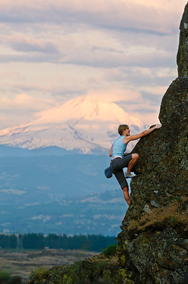
MOUNTAIN HIGH Elevate your summer by climbing at Washington’s Horsethief Butte, where the views and the crags are sublime.
Image: Mark Gamba
HORSETHIEF BUTTE
IT MIGHT BE a bit of a drive, but when the wet descends on Portland, this Columbia River Gorge treasure is still bathed in sunlight. Situated in the arid badlands just north of The Dalles in Columbia Hills State Park, the giant basalt butte stands like a sentry guarding 90-acre Horsethief Lake, whose dark waters conceal the spot where Lewis and Clark encountered a Native American village on their journey to the Pacific. After a half-mile hike through rugged meadows and a short scramble across a jumble of boulders, rock hounds will find themselves in a hidden amphitheater tailor-made for beginning climbers to top rope.
But Horsethief’s broken basalt bands also are short enough, and the landings generally flat enough, to merit forgoing the rope in favor of bouldering. Since there’s no guidebook to Horsethief, consider pairing up with someone who’s familiar with the area before you head out for the first time. On the other hand, it can be just as much fun to embrace your inner Meriwether Lewis and explore the endless chasms and bands that stretch out for more than a mile along the river. When you’ve had your fill, pick your way to the top of the butte and drink in the rare sight of a placid, blue-green Columbia as it pools just above the Dalles Dam before roaring, frothy and wild, to the west. —KC
- Get there: From The Dalles, cross the Dalles Bridge on U.S. 197 to Hwy 14. Head 2.5 miles east on Hwy 14 to a pullout on the right at milepost 85, marked by a small trail sign.
- Maps: Columbia River Gorge National Scenic Area Map
BEACON ROCK STATE PARK
ASK MOST CLIMBERS to name Oregon’s best climbing area and they’ll probably say, “Smith Rock.” Well, they can have it. Because while the crowds queue up to battle the heat and each other, we’ll be scampering up the Gorge’s signature stone monolith. Home to some of the Northwest’s best climbing, the 848-foot-tall Beacon Rock has more than 100 routes, including classics like the moderate Southeast Face. (Note, some areas are closed until mid-July to protect nesting falcons.) In 1952 the Southeast Face became Beacon’s first established route, and little wonder: Not only do its seven pitches offer a variety of climbing challenges, but the airy views you’ll get hanging from belays at, say, 200 feet, simply can’t be matched. When you top out near the hiker’s trail that delivers less intrepid types to the summit, you’ll have earned every right to feel a wee bit smug. —KC
- Get there: At Cascade Locks, take the Bridge of the Gods to Hwy 14 west. Follow signs to the park.
- Maps: Columbia River Gorge National Scenic Area Map; Portland Rock Climbs
MOUNT ADAMS
EVERY EVEREST DREAM starts small. It takes a little practice—and a lot of conditioning—to reach 26,000 feet. Enter Mount Adams, which, at 12,276 feet, is the third-tallest peak in the Cascades and a popular training ground for climbers with their eyes on the Himalaya. To join Portland mountaineering group the Mazamas on a two-day excursion up Adams’s beginner-friendly south side, you’ll need an ice axe, crampons, a reasonable degree of fitness, and a little experience. While the summit view of seven peaks (on a clear day) is certainly reward enough for the trek, it’s when you’re ready to head back down that the real fun begins: Glissading, aka sitting on your duff and sliding down the slope. That method of descent is so popular on Adams that, by July, chutes have formed in the snow, creating a kind of impromptu luger’s paradise. Simply remove your crampons, lie back, and schuss down 3,000 vertical feet in less than an hour. If that isn’t cause for a “Yee-haw!” we don’t know what is. —KC
- Get there: From Hwy 14 east, take Hwy 141 to Trout Lake and veer right onto Mt Adams Recreational Highway. After 1.3 miles turn left on FR 80 and go 2 miles to FR 8040. Follow for 6 miles to FR 500. Cold Springs Campground is 3 miles ahead.
- Maps: Green Trails Map No. 366

Wheelie Good
Portland’s Essential Annual Bike Rides and Events

Long Story Short
