Bonney Butte
WHY IT’S GREAT For 10 months of the year, Bonney Butte is a lonely place—a rocky, wind-worn ridge in the southeastern shadow of Mount Hood. But each fall the 5,500-foot peak becomes the nexus of an avian traffic jam: during September and October, some 4,500 birds of prey cruise overhead in what is thought to be the largest concentration of migrating raptors in the state. Nearly 20 species have been recorded here—among them golden eagles, sharp-shinned hawks, merlins, American kestrels, even the rare broad-winged hawk—each drawn by the butte’s thermal updrafts. So reliable is the display that members of HawkWatch International, a Utah-based raptor research group, have staked out the summit each fall since 1994. Feel free to sit alongside them and help count. You’ll need more than your fingers and toes to keep track, though: on good days, you’ll spy up to 200 birds.
POST-HIKE WATERING HOLE High Mountain Café Pair deli sandwiches like the turkey-, havarti-, avocado-, and cucumber-stacked Avalanche with fresh muddled sangria or one of nine bottled beers. 88335 E Government Camp Loop Rd, Government Camp; 503-272-3059; highmountaincafe.com
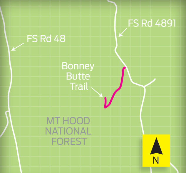
TRAILHEAD DIRECTIONS From Government Camp, head east on Highway 26, and turn onto Highway 35 north toward Hood River. Drive 4.5 miles to the White River East Sno-Park, and turn right onto Forest Service Road 48. Go 7 miles, and turn left onto the unsigned FS Road 4890. Drive 3.75 miles, and turn left onto FS Road 4891. Drive 4 miles up the rough, rutted dirt road, following signs for Bonney Meadows Campground. (Note: high-clearance vehicle required.) A few hundred yards past the campground, look for a gated spur road on the left. Park here and hike up the closed road to the observation point. No fees or permits required.
Find trails, news, tips, gear, and more at portlandmonthlymag.com/blogs/muddyboot or find a trail here.


