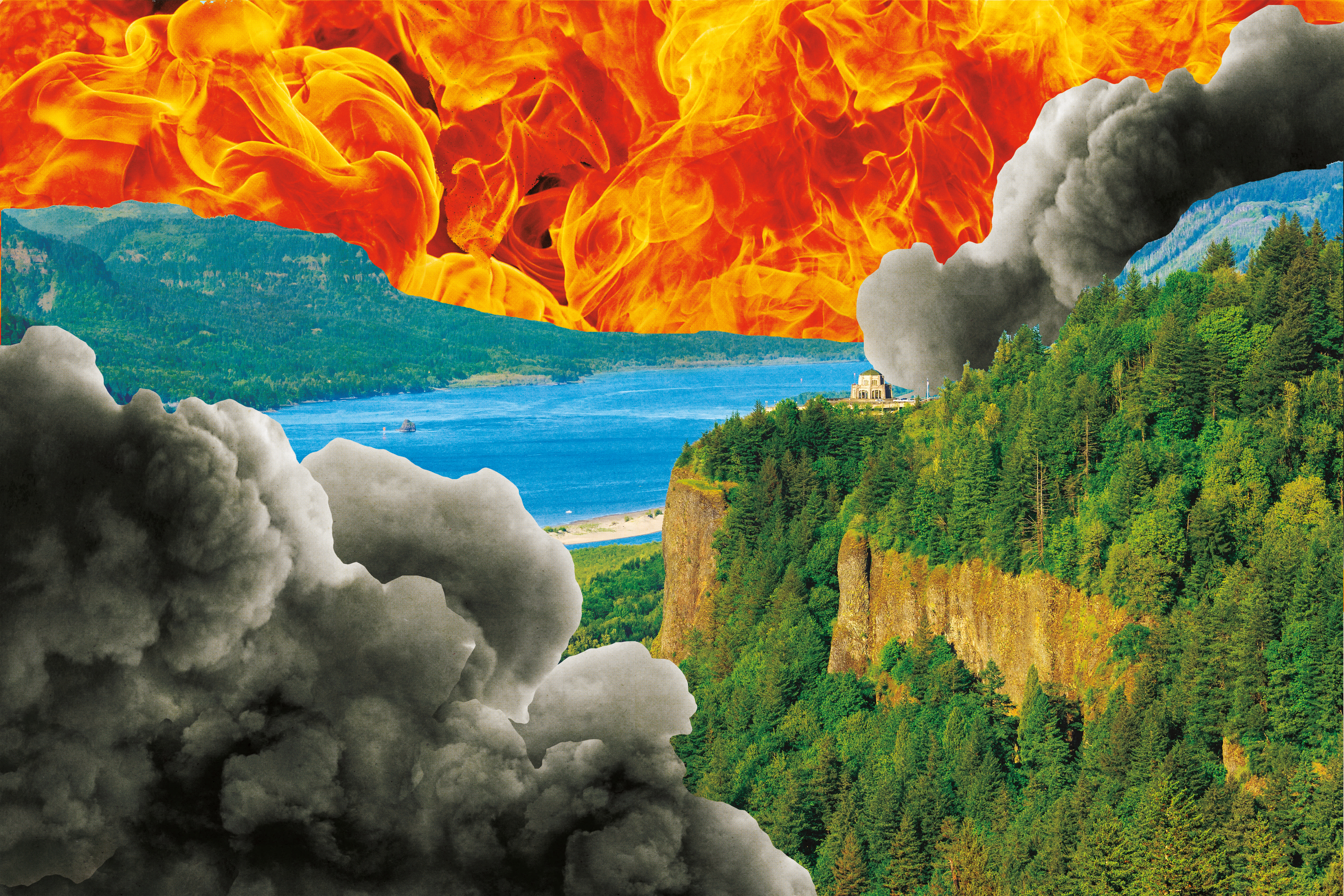
The Columbia River Gorge Burned. We Could Make That a Good Thing.
A little over a century before a smoke-bomb-tossing teenager allegedly sparked a fire that torched a wide swath of the Columbia River Gorge, lumbermen clear-cut it. The images of charred Doug firs and cottonwoods that emerged after September’s fire were tough to see. But a circa-1910s photo of Multnomah Falls shows the old-growth forest slashed to mere stumps. The Gorge survived that clumsy haircut to live another picturesque day. So, too, will it outlive its recent scorching.
Yes, the fiery photos and videos that raged across social media seared Oregon’s collective heart. Whole towns faced losing everything. Beloved trails and vistas—Eagle Creek, Oneonta Gorge, Angel’s Rest, to name a few—will take a generation to restore. Thick smoke and I-84’s 19-day closure choked Gorge tourism in a vital season. A predicted La Niña winter could unleash perilous landslides and debris flows.
In the long run, however, the Eagle Creek blaze may yet prove more of a gift to the Gorge than a tragedy. “The only thing that would have been better is for it to have happened 40, 20, or even 10 years earlier,” says Robin Dobson, longtime ecologist with the US Forest Service’s Columbia River Gorge National Scenic Area Division. “Fire is what makes the forest resilient. It isn’t the enemy. It’s part of a system.”
That “system” has grown into a unique amalgam of roads, rails, trails, dams, cities, and attractions that have shaped one of the most visited, industrialized, and populated scenic destinations in the world. Northwest historian Richard White most aptly described the river and the Gorge as “The Organic Machine.”
The fire got our attention, reminding us how treasured and vulnerable the Gorge is for visitor and resident alike. With many of the most popular hiking trails and large stretches of the Historic Columbia River Highway closed indefinitely, we have an unexpected opportunity to pause and reflect. The 1986 Congressional act that established the Columbia Gorge Scenic Area—limiting development and protecting wild land in a 290,000-plus-acre area also studded with cities, towns, dams, and ports—required a governing management plan, to be updated every decade. The current revision is now four years overdue; in general, the plan has never accounted for now-imminent changes and threats that could transform the Gorge more drastically than any smoke bomb.
“This is a planning opportunity you don’t often get,” says Kevin Gorman, executive director of Friends of the Columbia Gorge. “It’s not a blank canvas, but we now have some room to rethink.”
Nature and humans codesigned the Gorge landscape. We now need to redesign it.
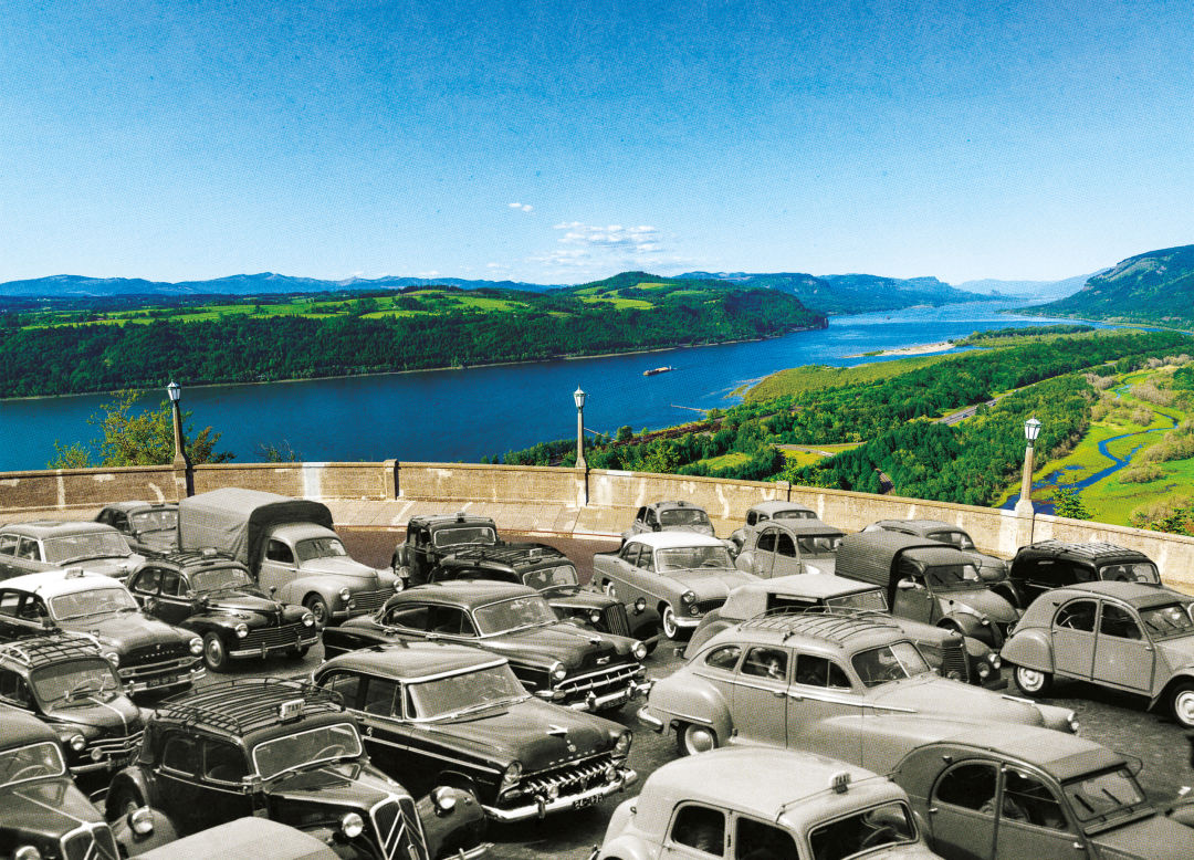
Image: Amy Martin
Efforts to balance beauty with commerce in the Gorge tend to run long on grand visions, but have often demanded last-minute saves. In the 1910s, a Seattle railroad entrepreneur, Sam Hill, led the charge to build “America’s first scenic highway.” Road designer Samuel Lancaster elegantly curved the road along, around, and through the Gorge’s cliffs. John Baptiste Yeon, a former lumber baron, worked shoulder to shoulder alongside 2,200 men, many of them immigrant Italian stonemasons, to craft basalt escarpments, arched-concrete guardrails, and bridges, even working around especially picturesque trees.
Meanwhile, the Columbia Highway’s scenic crescendo, Multnomah Falls, remained in private hands. In 1915, the City of Portland—with another timber magnate, Simon Benson, paying the bill—exerted eminent domain over a Washington, DC, owner who imagined one of the highest falls in the country would make a pretty good power plant.
The highway instantly clogged. The Oregonian described the first “inspection day,” September 7, 1915: “There were big, powerful cars, medium-sized cars, and tiny little cars; brand-new, glittering cars of the 1916 model, middle aged cars and spavined old wrecks that coughed huskily at every grade, and auto trucks from Portland business houses, whole fleets of them, loaded to the rails with pretty girls who blew horns in your ear when you tried to pass them.”
In the early ’30s, as highway engineers angled to widen the highway and construction began on the Bonneville Dam, Yeon’s son, also named John, chaired a committee charged with creating a plan to preserve the Gorge’s “scenic resources.” In two detailed volumes, the committee outlined a sweeping agenda of land acquisition, road design, and view protection. The report soon “disappeared into a black hole,” the younger Yeon later recalled. But the committee successfully thwarted an end run by Portland industrialists who wanted power-pricing incentives that would have spawned, as Yeon put it, “a second Pittsburgh” in the Gorge.
Yeon and other conservationists spent decades trying to establish the Gorge as a national park. That proved out of reach. Even the considerably weaker Scenic Area act, which mandates special protections and management structures, almost never came to be. In a recent essay, Bowen Blair, the chairman of the Columbia Gorge Commission (and founding director of the Friends), recalls how Sen. Mark O. Hatfield, a legendary Oregon Republican, bulldozed the law through Congress using legislative trickery that might make Mitch McConnell blush. Hatfield even held hostage Ronald Reagan’s beloved missile-defense initiative, nicknamed “Star Wars,” to motivate the Gipper to sign the law. Meanwhile, Yeon and Friends founder Nancy Russell had already narrowly saved several now-iconic Gorge destinations—Steigerwald Lake, Cape Horn, and Archer Mountain among them—by purchasing them before the act passed.
The scenic area and management plan “were powerful steps,” according to Dobson. “We essentially said we want to protect the scenic and habitat values, but not always how.” Indeed, close reading of the management plan finds many aspirations often lacking clear paths to realization. What’s unfolding, Dobson and other conservationists worry, is “a slow degradation, one parcel at a time.”
The Eagle Creek fire actually behaved about as well as we might hope a fire would. Flames leapt from ridge to ridge, leaving what forest ecologists describe as “mosaic” of burns, a pattern that could foster much healthier and more diverse growth. Left alone, the forests will heal. Beetles and carpet ants will burrow into the charred tree remains, attracting woodpeckers, chickadees, and meadowlarks. Freed of towering Douglas firs and thick cottonwoods, more diverse meadows and hillsides will emerge. Oaks will get some breathing room. More butterflies could return. The progress will be slow.
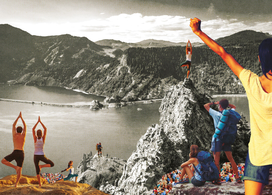
Image: Amy Martin
Humans, however, tend to hurry. As the fire burned, the Friends of the Columbia Gorge’s Facebook friend count ballooned from 14,000 to 30,000 in six days; more than 1,000 ponied up at least $35 to become new members. More than 3,000 people signed up to work on trail restoration with the Friends and the Trailkeepers of Oregon. Oregon Congressman Greg Walden quickly introduced the Scenic Columbia Gorge Restoration Act to “expedite salvage and reforestation projects” and “achieve reforestation of at least 75 percent of the impacted lands” within two years. At Portland cocktail parties, old-timers wistfully imagined a redux of the legions of schoolkids and inmates who, after three major fires torched the Tillamook Forest in the ’30s and ’40s, planted 72 million seedlings.
But like human burn victims, scorched forests are prone to further damage and infection. Too many boots and wheels on the ground—whether salvaging lumber, planting trees, or restoring trails—can track in invasive species and smash native seedbeds that survive fires.
“The question really is,” says Gorman, “how do we make all the urges to help the Gorge more meaningful?”
Indeed, the harder work of restoring the Gorge—and the political muscling to continue saving it—requires a much longer game. A 1989 redesign of Multnomah Falls offers a case study. At the time, authorities estimated that busy summer days saw as many as 370 cars squeezing into 237 parking spots, with somewhere between 1,200 and 1,400 people crowding the plaza at any one time.
Mike Abbaté, then a Forest Service landscape architect (and now director of Portland Parks & Recreation), recalls that surveys showed visitors were generally happy. But he believed those polls neglected “unheard voices”: those who visited once, never again to return after being repelled by the crowds. He and his team analyzed every element of a visit, from squeezing through trail choke points to lining up to use the 23 urinals and toilets. They determined that the 27,000 square feet available at the falls was enough for 1,200 PAOTs—Persons At One Time. To expand that capacity, they relocated concessions and redesigned the plazas to foreground the beauty of Multnomah Falls Lodge, the plant life and geology, and the 542-foot-tall cataract above. A huge blinking sign at I-84’s Multnomah Falls exit flashes to warn travelers when the parking lot is full.
The Historic Columbia River Highway, projected to be closed at least through this winter, offers the ripest opportunity for a similar reboot. Warm, clear days in recent years recall the scenes described in the 1915 Oregonian. Current trends leave little doubt summers will get even more hectic. Over the last 20 years, ODOT gradually restored a 13.5-mile stretch, reserving it for bikes and pedestrians only. (Unfortunately, that segment took some of the fire’s worst hits. Oneonta Tunnel, excavated and lined with new timbers in 2009, went up in flames.) The rest of the highway’s overcrowding, according to ODOT’s Don Hamilton, has prompted ideas ranging from making the route one-way to allowing only buses and bikes. A pilot bus program started in 2016, offering round-trip service linking the Gateway Transit Center with Rooster Rock State Park and Multnomah Falls. Over two years, the Friday-through-Sunday summertime service attracted more than 56,000 passengers.
Elsewhere, Gorman notes that some of the trails affected by the fire are more than 100 years old and were never imagined for the hordes of hikers seen in recent times. He hopes to channel fire-fueled Gorge enthusiasm into an expansion of the trail system: into the less-traveled eastern Gorge, and more directly to towns and cities through the Friends’ “Towns to Trails” initiative.

Image: Amy Martin
Managing development will be, as it always has been, a tougher assignment. With the last major update completed 14 years ago, the Scenic Area’s management plan is woefully behind the curve of change. The population of Hood River County has surged from less than 17,000 in 1990 to more than 23,000 in 2016; Washington-side counties Skamania and Klickitat are growing, too. New development outside of Scenic Area cities is supposed to be “visually subordinate” from “key viewing areas” like Cape Horn and Dog Mountain Trail. But existing rules neglect important vistas from Angel’s Rest in Multnomah County, The Dalles Mountain Road in Washington’s Klickitat County, and US Highway 197 in Wasco County—the only major portal into the Gorge that is not designated as a key viewing area.
Meanwhile, some major modern-day issues are completely absent from the current plan. The only mention of trains is a fantasy line to someday deliver tourists—not the 100- to 120-car oil trains that now course through on an almost-daily basis, one of which derailed and exploded in Mosier in June 2016. (That conflagration caused an interstate closure and evacutions; the wind wasn’t blowing that day, so it could have been much worse.) “Climate change” and “invasive species”—equal, if slower-moving, dangers—are similarly missing from the current plan.
Then, there is money. Washington and Oregon set contributions to the Columbia Gorge Commission’s bistate budget by whomever wants to pay less: currently, if inflation-adjusted, 12 percent below the commission’s first budget in 1987. The commission currently lacks the funds to create sufficiently sophisticated land inventories and computer models to demonstrate what proposed developments and regulations could look like. Planning decisions made by the commission are implemented by local governments—subject to local pressure.
As two governors and two state legislatures look to help the Gorge recover from the fire, a good place to start would be to more realistically fund the governing body the Scenic Act created to oversee the Gorge’s future. And the volunteers readying their picks and shovels to fix the damage need to understand that the Gorge’s longer-term health will be shaped not by work crews but by astute leaders backed (and nudged) by well-aimed emails, testimony, and checks.
With the long view of an ecologist—one who has monitored the Scenic Area for 25 years—Dobson argues that our relationship with the Gorge really demands a deeper “land ethic.” That, he emphasizes, is a generations-long effort. We can measure the past successes—lucky as they often were—by the instinctual pain felt watching the Eagle Creek fire burn. This complicated landscape’s future will inevitably bedetermined by the Gorge’s growing number of Persons At One Time. Either we design the outcome, or they will.
Randy Gragg is the former editor in chief of Portland Monthly and the coeditor of John Yeon Landscape and John Yeon Architecture (Andrea Monfried Editions, 2017).
Long Story Short
At 80, Photographer Sergio Ortiz Is Still Seeking Wonder

from the archive
Making a Scene

Institutions
10 Must-Visit Museums in Portland

Fire Season