
Does Oregon's Vanished Coastline Hold the Secrets of the First Americans?
The morning I meet Loren Davis, he’s running late due to the rarest of situations: a sudden and immediate need for an archaeologist. An excavation crew working on Oregon State University’s football stadium has discovered enormous prehistoric bones beneath the end zone. Davis seems to be the only person on campus with the credentials, so he arrives out of breath and in full dig-site regalia, his bright orange rubber waders plastered in muck.
“It’s a mammoth,” the OSU professor of anthropology says: a creature that roamed prehistoric North America alongside proto-camels and “mega beavers” that stood six feet tall on their hind legs. “Not really my thing. It’s just paleontology. There are no artifacts.”
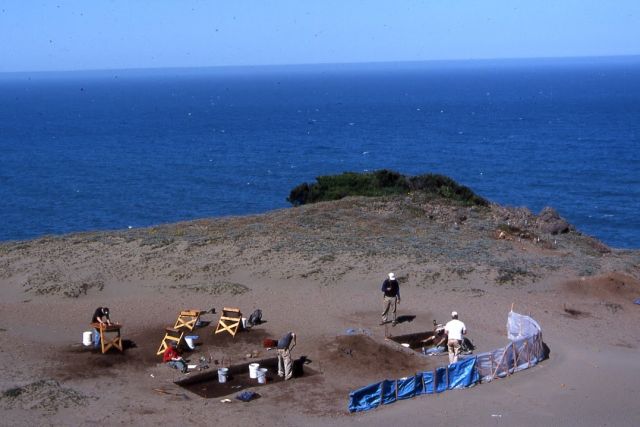
OSU archaeologists excavate at the Indian Sands site near Brookings, Oregon
Image: Courtesy Loren Davis
Artifacts—signs of human activity—are what Davis chases professionally. And while he spent this morning waist-deep in Corvallis dirt, his mind is at the bottom of the ocean, along what was once Oregon’s shoreline, now under 400 feet of water. Back in that mammoth’s day, the landscape around Florence, for example, extended another 35 miles to the west, laced with huge, rushing rivers running to a jagged, bay-filled coastline.
Davis hopes to probe that lost world, conducting the Oregon leg of an unprecedented search for artifacts that illuminate early migration along the West Coast. Such evidence could bolster the idea that the Americas’ first human inhabitants arrived much earlier than once assumed, proceeding not down an inland path through Canada (as long thought) but down the Pacific coast by boat until they reached a resource-rich land that wasn’t covered in ice: Oregon. “If we find artifacts, that is super-exciting,” Davis says. “No one has ever seen that kind of [archaeological evidence] in our part of the world.”
Until the 1980s, almost all archaeologists believed that North America was settled by people who crossed the Bering Strait from Siberia and continued down through present-day Alaska, the Yukon, Alberta, and finally, eastern Montana—a theory known as the Clovis model, named for a town in New Mexico near an artifact-rich dig site. Researchers hypothesized that humans moved through a “deglaciation corridor” around 13,000 years ago, only after a gap melted in the ice, perhaps more than a mile thick, that blanketed Canada.
Without setting out to, Davis has spent his career chipping away at this model. The clean-shaven, silver-haired 47-year-old grew up in Gladstone, Oregon, digging up his family’s pet cemetery and reassembling the pieces in his backyard. (“My parents were maybe a little worried about me at first.”) His first breakthrough came while working on his doctoral degree in 1997 at a site called Cooper’s Ferry in western Idaho, near Hells Canyon. Davis and his team found what was then some of the earliest evidence of humans in the Pacific Northwest, dating to 13,000 years ago: stone tools, animal bones, and campfire hearths. The site is so rich—spanning roughly 4,000 years of hunter-gatherer migration—that he and his field research students are still excavating it today.
From 2004 to 2009, Davis worked with the University of Oregon’s Dennis Jenkins to unearth even earlier evidence of humans in the Northwest. At the Paisley Caves site, 130 miles southeast of Bend, they discovered and DNA-tested human coprolites (fossilized feces) from between 14,000 and 14,500 years ago; the caves basically served as a primordial outhouse. Most geologists agree that the ice-free corridor of the Clovis model melted between 12,000 and 13,000 years ago. But well before then, as Davis eloquently puts it, “people were already taking a dump in Oregon.”
The dates and location imply that migrants arrived in the Americas well before the big melt, possibly using the coastal corridor as their path into a very new world—and dozens of similar discoveries have been made. Just this May, the journal Science Advances reported that 14,550-year-old artifacts demonstrate that humans butchered mammoths at a site in Florida. In sites as far south as Chile, items have been found potentially dating back to 18,500 years ago. The new thinking asserts that if proto-Americans had migrated all the way down to the Southern Cone by that time, the ice-free model couldn’t have been their first route.
James Dixon, the freshly retired director of the Maxwell Museum of Archaeology and a professor of anthropology at the University of New Mexico, says most specialists now see things Davis’s way. “A lot of people still believe [in the ice-free corridor model]; it’s still taught by some professors,” Dixon says. “But there’s been a paradigm shift in the past 30 years.”
The new model suggests that rather than walking across a land bridge, the early migrants used boats to hop from bay to bay. David Madsen of the University of Texas is analyzing evidence of a vast, ancient trading network in obsidian suggesting that 30,000 years ago, explorers from the Siberian Japanese islands used boats to probe the Northwest Pacific Coast. “The fact that people were there that early makes me think they would have almost had to have spread into the Americas before [the Clovis sites],” Madsen says.
In July 2015, Davis was one of many coauthors of a paper published in the journal Science that compared genetic information from ancient specimens with modern-day indigenous communities. The researchers discerned that the ancestors of today’s Native Americans probably migrated in over a relatively short period of time—on the order of decades or a few centuries—as long ago as 23,000 years, and that they originated from a single, coherent population before diverging into different groups once they were here. Davis’s part in this project was minor: he helped identify ancient skulls in northwestern Mexico. But the work left him even more convinced that evidence of America’s first inhabitants—and their entry point onto the continent—might be found in Oregon’s waters.
Discovering ancient remains at the bottom of the Pacific Ocean will be as hard as it sounds. Even if you single out a likely archaeological site, artifacts—stone tools, bones, clothing—will have been tumbled, buried, and eroded for tens of thousands of years.
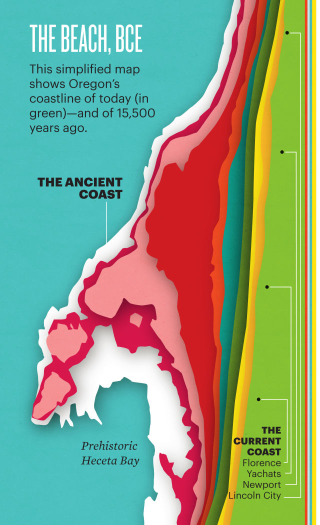
To narrow the search, Davis used a computer model to reconstruct the map of the ice age sea, when Oregon’s now relatively straight coastline was 400-plus feet below present-day levels. His simulation revealed Heceta Bay, an ancient body of water larger than San Diego Bay, lying west of modern-day Florence. This, says Davis, is the sweet spot. “Think like a hunter gatherer: there are more calories per square foot in a coastal environment than anywhere else in Oregon. Most of the archaeological sites we’ve discovered are concentrated around estuaries.” Davis is on the hunt for middens: giant piles of shells, the possible refuse of a maritime culture that likely subsisted primarily off of Oregon’s rich cache of mussels, clams, and oysters. Such piles might contain preserved human artifacts.
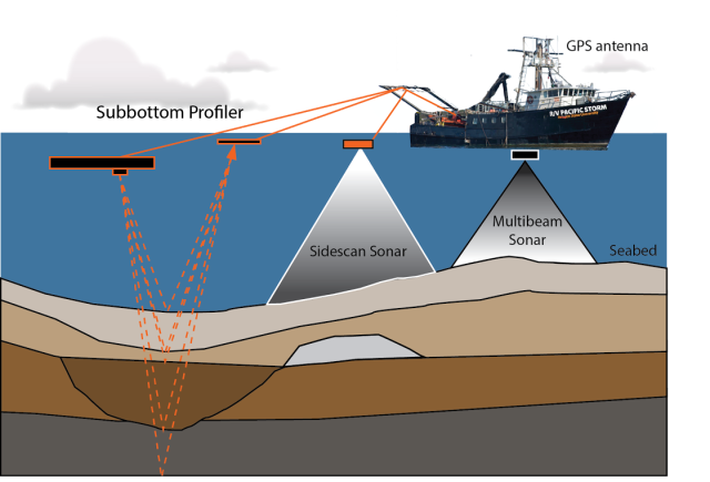
Diagram showing the use of remote sensing tools that will be used to search for submerged archaeological sites
Image: Courtesy Loren Davis
Reaching the submerged coastline presents challenges. At depths impractical for scuba divers to explore, Davis and his team plan to use a Tow Fish—essentially a sonar torpedo—dragged from the back of a boat, to give them a level of three-dimensional exactitude down to the nearest meter. This will be the first time anyone has chronicled the Oregon coast in such detail.
Next, Davis plans to take core samples at the site using a device called a “Vibracorer”: his team will drop a long pipe loaded with weights off the back of the ship and let gravity and a vibrating motor go to work: the pipe jackhammers into the seafloor and seals shut at the bottom before being hauled back up to the surface using a massive winch. “Imagine taking a large-diameter straw and putting it through a layer cake,” Davis says. “Put your thumb on the end and pull it back out; all the layers inside the straw come out perfectly aligned.”
There’s a reason that no one has done this kind of research off the West Coast before: underwater sonar probes and ships capable of lifting tons don’t come cheap. Thanks to a renewed interest in alternative and independent energy from the Obama administration and long-standing protocol to investigate potential sites for archaeological resources on federal land, the federal Bureau of Ocean Energy Management is doling out almost $900,000 in funds for the project. In May, Davis’s team also won a highly coveted grant from the National Oceanic and Atmospheric Administration’s Office of Exploration and Research.
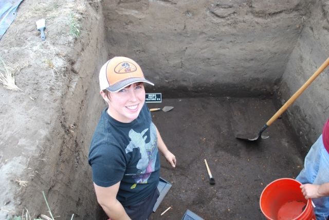
OSU archaeologist Jessica Curteman excavates at the Devil's Kitchen site near Bandon, Oregon
Image: Courtesy Loren Davis
As coprincipal investigator and top dog in Oregon, Davis plans to launch next summer, while the lead team of researchers, headed by San Diego State University’s Todd Braje, has already begun to scour the seas off California’s Northern Channel Islands. Not everyone shares his optimism. “A lot of scientists believe this money would be better spent on land, or they don’t buy the hypothesis,” says the University of New Mexico’s Dixon. “I’ve heard several say, ‘This is the most ridiculous thing I’ve ever heard.’”
Davis might be the first person to try this sort of deep-sea archaeology in Oregon, but others have had success around the globe, from the North Sea to Southeastern Alaska. In 2014, near Haida Gwaii, an archipelago that’s part of British Columbia, Davis’s colleagues Quentin Mackie and Daryl Fedje uncovered what might be a 13,700-year-old fishing weir—a stone structure for catching fish—using similar methods. Dixon did a survey of the Bering Sea himself in the late 1970s before bathymetric (underwater depth) maps even existed for the area.
What are the odds that Davis will actually find something? “If it was impossible, we wouldn’t try it. But it is kind of like going to the moon,” says Dixon. “When you stand on a ship and look out on that vast, expansive ocean in every direction, and you’re looking for something that’s the size of a quarter at the bottom ... well, it’s a very daunting task.”
Illustrations by Amy Martin.

ARTIFICIAL INTELLIGENCE
A Furry, Confused, Emotionally Demanding Robot Is Wandering the Halls of Wieden & Kennedy


SONIC ARCHITECTURE
These Sonic Installations Provide a Soundtrack to the World


from the archive
Making a Scene

The Organ Trail
