Oregon's 6 Essential Rivers
MORE THAN 114,000 MILES OF RIVER cut across Oregon’s landscape—plunging and meandering through arid desertscapes, fortresses of prehistoric basalt, and verdant canyons bursting with cedars and firs—all bound, eventually, for the Pacific. Some of our twelve thousand waterways are shadowed by highway blacktop; others are escorted by little more than the whisper of wind through sagebrush; and fifty-five of them are accorded the promise of protection by the Wild and Scenic Rivers Act.
Like national parks, Wild and Scenic rivers are safeguarded to preserve the country’s most outstanding free-flowing waterways—rivers, or parts of rivers, that must be shielded from overdevelopment because they are culturally significant, recreationally important, or simply too beautiful to neglect. Only eight rivers in the country (one in Oregon) were anointed with the title when the designation was adopted by Congress in 1968. Today, Oregon has more federally designated Wild and Scenic segments of river than any other state.
Exploring all fifty-five rivers could take a lifetime, so we’ve culled the list to an essential six. Our criteria? Natural splendor, of course, but also the quality of the experience, whether paddling, hiking, mountain biking, or fishing. Each of these gems is a world-class destination for one, if not several, of these pursuits—and each is accessible to all kinds of adventurers, even if your only river equipment is a pair of water wings. Most can be easily enjoyed on guided float trips or riverside trails, two can be traveled by jet boat, and one can even be reached by airplane. Our aim, after all, is to get every Portlander out of the city—and into the water.
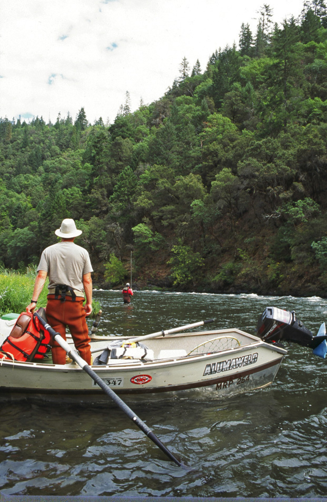
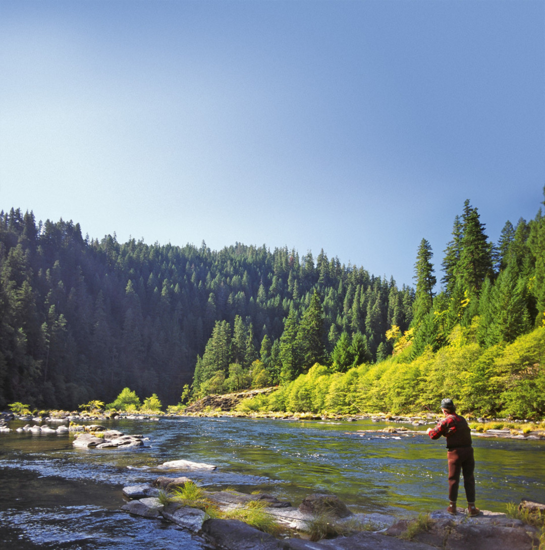
Prime fishing turf on the middle Rogue.
Image: John Shewey
THE ORIGINAL
Rogue
“PURE AS THE SNOW FROM WHICH IT SPRANG, the river had its source in the mountain under Crater Lake,” wrote Zane Grey of the Rogue’s 215-mile journey from the Cascades to the sea in his epic novel Rogue River Feud. The famed Western (or, in the case of this book, Northwestern) author lived in a log cabin on the Rogue’s banks until the popularity of his prose drew so many visitors to the river that he picked up and moved to the North Umpqua (see “Rogue Tales”). Because parts of the Rogue were among the original eight stretches of river to be designated Wild and Scenic by Congress in 1968, you can still experience the river much the way Grey knew it. The lower canyon is one of the few places in the country where you can float for four days without even glimpsing a road. That doesn’t mean you’ll have the river all to yourself, though. The canyon’s remoteness and abundant fishing attracted hordes of sportsmen long before it received federal protection. Plus, the steep, forested slopes and impossibly narrow gorges that flank the river and its surging white water put the Rogue on most paddlers’ life lists. Fortunately for them, the Rogue has the longest river-running season of all of Oregon’s wilderness rivers, a fact attributable (rather ironically) to its four dams, which ensure boatable flow in the lower canyons year-round. But the dams are increasingly an endangered species. Later this year, the Savage Rapids Dam on the upper Rogue will become the widest dam removed in Oregon, and in July 2008, the Gold Hill Dam, upstream of Grants Pass, was demolished to ease salmon and steelhead migration. In fact, given the size and relative health of its watershed, the Rogue is arguably the last significant salmon stream in Oregon south of the Columbia River. Each year, a hundred thousand hatchlings follow the same route down the river that Grey described in 1929, winding “past the picturesque farms of the Indians and the rude shacks of the fishermen, broadening and meandering, smiling from its shiny pebbled bed at the retreating banks and the low colorful hills, and so on down to Gold Beach, assuming a deep, calm majesty when it found its home in the infinite sea.”
PADDLE The lower ninety miles of the Rogue—the last few practically within sniffing distance of the Pacific Ocean—are frequently run by paddlers, kayakers, and tubers. But the river’s real jewel is the stretch of thirty-five roadless miles carved into the Siskiyou Mountains between Grave Creek and Foster Bar. Here, moderate rapids like Coffee Pot—where water boils through a narrow rock chasm—interrupt generous doses of serene drifting. And broad, sandy beaches beckon picnickers and hikers who can head for mesmerizing spots like Whisky Creek Cabin, a relic mining camp still filled with tools from the 1800s. The bad news: only 120 people per day are awarded permits to float this section of the river each summer—and half of the permits go to guides. Outdoor Adventure River Specialists, or OARS, runs a four-day camping and rafting trip (oars.com; $880). The dirt-averse might try OARS’ three-day Rogue River Lodge Trip ($806); you’ll get the same wild river experience, but at day’s end, you’ll enjoy showers, fresh towels, and clean sheets at riverside wilderness lodges. Those on a tighter schedule can just zip through the canyon aboard jet boats that make day runs down the fifty-two miles between Gold Beach and Blossom Bar (roguejets.com; $87).
HIKE Gold miners first blazed the forty-mile Rogue River Trail during the 1851 Gold Rush, hauling out more than $70 million worth of ore. But only recently has this dramatic segment along the river’s north bank between Grave Creek and Foster Bar become a well-trafficked hiking destination. Many backpackers choose to traverse the route on their own, dipping down from the canyon walls to campsites along the river’s bank. But in May, June, September, and October (when temperatures don’t hit triple-digit summertime highs), Rogue Wilderness Adventures offers a stunning four-day trip (wildrogue.com; $949) that includes a guided raft to haul your gear from one riverside lodge to the next while you scamper up the ridges with nothing but a light day-pack to weigh you down. The best part? Trekkers with land-weary legs can always hitch a ride on the raft.
Rogue Tales

Zane Grey: author, fisherman, conservationist.
Image: Grey Family
Long before Johnny Cash made our ears tremble, Zane Grey introduced readers to Jim Lassiter, the original man in black. Grey was one of the preeminent architects of the hardscrabble mythos of the American West; his 1912 book Riders of the Purple Sage was a model for the western tales that followed it. All told, he wrote more than eighty novels before his death in 1939, provided fodder for more than 110 films, and inspired a 1950s television show, Zane Grey Theater.
But beneath Grey’s tales of tough frontier heroines and dusty, taciturn men was an eloquent argument for environmental protectionism. “The main characters in his novels were always the environments themselves,” says Eric Grey, the writer’s great-grandson, who lives in New Jersey.
The Oregon wilderness was one of the landscapes lauded by Grey, perhaps nowhere more famously than in Rogue River Feud. “It’s a total environmental story,” Eric says. “It’s these downriver canneries versus these upstanding, decent folks who are living in balance with nature. It’s so conservationist, you think, ‘Wow, this guy is really ahead of his time.’”
According to his great-grandson, Grey paid many visits to the places he was preparing to write about. For instance, Grey spent eight years fishing the Rogue before penning Rogue River Feud. On one 1925 trip down the lower Rogue, Grey’s fishing party spent a brief, happy day at a miner’s claim called Winkle Bar. Zane Grey loved it so much, he bought the land from the miner the following year and built a fifteen-foot-by-twenty-seven-foot cabin there.
It’s still standing today, and you can visit it—if you know where to look. About half a day’s hike and two days’ float from the put-in at Grave Creek, Grey’s cabin sits approximately three hundred feet back from the water at a bend in the river, its front porch facing the Rogue. Last May, the site became public property after the Bureau of Land Management purchased it from the Trust for Public Land.
“From all the fans I’ve talked to, that cabin helps them discover Zane Grey,” the author’s great-grandson says. “But more importantly, I think it helps them appreciate the Rogue more, because this is a river that inspired a work of art—it’s worth protecting.” —Alexis Rehrmann
For our slideshow of Grey’s photos and writing, please visit Rogue River Feud.
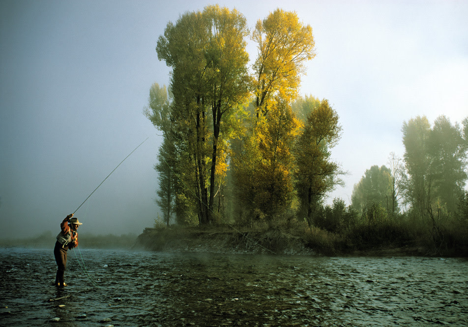
Casting near “Camp Water.”
Image: John Shewey
THE FISHERMAN’S RIVER
North Umpqua
THE SLICE OF LINE THROUGH SKY, the gentle kiss of fly and river, the quiet inhale of the back-cast—the North Umpqua’s siren is a powerful call, for there may well be no river in Oregon more synonymous with fishing than this. But the North Umpqua hasn’t always been fishermen’s favored stream. The emerald river piggybacked its way to fame on the shoulders of the Rogue thanks, in part, to Zane Grey. Beginning in the 1920s, anglers looking for pristine waters staked out camps for the summer on the banks of the North Umpqua, generally complete with a cook and a caretaker. Grey followed in the 1930s to escape the relative crowding on the Rogue River that his own work had helped create. His campsite at the North Umpqua’s confluence with Steamboat Creek eventually became the location of the legendary Steamboat Inn (see “Lodge Legacy”). Today, the river still draws anglers from across the region, particularly during the summer steelhead season. Long known as a purist’s proving grounds, the thirty-one miles in the heart of the North Umpqua’s upper canyon, near the inn, were some of the first public waters designated for fly-fishing only—no live bait, no lures—in 1952. In order to decrease pressure on the fish population, the Department of Fish and Wildlife also prohibited casting from rafts or drift boats. Instead, anglers must practice their art from the banks, or wade into the deep water, which is punctuated by plunging rapids. It can be treacherous, tedious fishing—and rhythmic and soulful and rewarding. So much so, that every year two thousand fishermen return to the fir-flecked banks along this stretch of the North Umpqua, unpack their flies and ties, and play their solitary song.
FISH The North Umpqua boasts one of the longest summer steelhead seasons in the world, lasting from June until November. As the river winds through steep canyon walls, it offers every imaginable version of steelhead Eden: from bedrock-rimmed chutes to choppy runs and deep pockets of water. The entire river is open for fishing, but the central thirty-one miles between Soda Springs Dam and Rock Creek are reserved for fly fishermen only. The stretch of river near the Steamboat Inn has been called “the most celebrated water in all of steelhead fly-fishing” by steelhead guru Trey Combs. Virtually every piece of river here has a story—from Kitchen Pool, named in honor of the cook tent of the Umpqua’s first camp denizen, Major Jordon Lawrence Mott; to Takahashi, named after Zane Grey’s Japanese cook, George Takahashi. The best spots may seem obvious—well-worn trails dive down from roadside pullouts directly to the river—but even there, the steelhead can be elusive. Eliminate the guesswork with Steamboat Inn’s preferred guide service, Summer Run (summerrun.net; full-day $400, half-day $200).
HIKE/BIKE Only forty-three rides in North America have earned the International Mountain Biking Association’s esteemed designation as “epic.” The seventy-nine-mile-long North Umpqua Trail is one of them. Built as a multiuse trail for hikers, bikers, and backpackers, the ride follows the North Umpqua river as it meanders through old-growth forest, past hair-blowing waterfalls, across narrow ridges, eventually crisscrossing the small stream itself several times near the headwaters at Diamond Lake, just north of Crater Lake National Park. Most cyclists tackle afternoon-long sections, but Western Spirit Cycling Adventures runs a five-day tour that includes meals and shuttles for your gear (westernspirit.com; $1,185), so all you have to worry about is keeping your eyes on the trail—and the breathtaking landscape, of course. (Note: This year the westernmost sixteen miles of the trail are closed beginning at the Swiftwater Trailhead for maintenance, so start your ride at the Wright Creek Trailhead instead.)
PADDLE Whether swelled from spring rains or snowmelt, North Umpqua tributaries like Copeland and Canton Creeks attract expert kayakers. But the main river, with its deep pools sitting behind short bedrock rapids, can be run year-round. Ouzel Outfitters, known for its long-tenured and knowledgeable guides, runs a two-day all-inclusive trip (oregonrafting.com; $325) that tackles the twenty-five rapid-packed miles between Boulder Flat and Susan Creek Campgrounds. Get your buzz on the steep upper segment, bouncing through Class III rides like Cardiac Arrest, Toilet Bowl, and Pinball as the river winds through a mountainous canyon lined with lichen-draped trees; then get your tan on the mellow lower section, where the river gurgles past stands of fir and cedar.

Tamolitch Pool, where the McKenize reemerges from its underground passage.
Image: Scott Larson
THE MAGICIAN
McKenzie
ON THE MCKENZIE’S SIXTY-EIGHT MILE journey from just west of Sisters to Springfield, the river tumbles 2,561 raucous feet over waterfalls, past hot springs, and through six-hundred-year-old stands of Douglas fir—but the most intriguing section may well be the three miles that contain no water at all. West of the river’s headwaters at Clear Lake, the McKenzie, once an angry torrent draining the Cascades, dips suddenly below ground, leaving in its place a rocky, meandering depression cluttered with leafy alder trees. Three miles later, it reemerges as Tamolitch Pool, a pristine one-acre aquamarine basin that spills westward for another fifty-eight miles to meet the Willamette. Rivergoers can thank the likes of Pele for this geological game of hide-and-seek. About 1,500 years ago, the nearby Belknap volcano spewed lava into the river, covering the McKenzie and sending it underground. A similar eruption 3,000 years ago dammed the river to create Clear Lake, 200 feet deep. Between these two fire-forged water features lie thirteen miles of Wild and Scenic river punctuated by two towering waterfalls—the 140-foot Sahalie and the 70-foot Koosah—and more than enough adventure to make up for those three waterless miles.
HIKE/BIKE For those who prefer to witness the river’s beauty from dry land, the McKenzie River Trail is one of the best mountain-bike rides in Oregon. It descends nearly 1,750 feet down the lava flows of Clear Lake, past the high-rise falls of Sahalie and Koosah and the dry riverbed above Tamolitch Pool, and finally through the towering old-growth forest near the town of McKenzie Bridge. The path has plenty of easier, upright pedaling between all the sharp rocks that line the track. Fraught with steep, rock-choked descents and slippery bridge crossings, the twenty-six-mile trail may be too technical for some riders, so in that case, ditch the bike, lace up your boots, pick a section, and start hiking. For the most scenic payoff, take the Clear Lake Loop Trail, where you’ll find an eerie array of coral-like lava that bubbled right up to the water’s edge, and three-thousand-year-old petrified tree trunks poking up from the lake’s depths like the posts of an ancient abandoned pier.
FISH Although not as famed for fishing as the Deschutes or the North Umpqua, the McKenzie has a bonus neither of those rivers share: it’s legal to fish from a boat. That means you can cover more water and, if the fish aren’t biting in one spot, cast your line elsewhere. Near Eugene, the river flattens and spreads out, meandering swift and clear over riffles that make it ideal for trout fishing. Although the McKenzie contains salmon and steelhead, anglers covet its famous redband, a variety of native rainbow trout (although you can’t keep these). Your best bet for catching them might lie with guide Aaron Helfrich (helfrich.com; $275/half day), whose family has been guiding on the McKenzie for more than eighty years.
PADDLE While Sahalie and Koosah Falls remain experts-only paddling turf, 17.5 miles downstream, near McKenzie Bridge, the river offers a fine beginner’s sampler with long, placid stretches of water interrupted by exhilarating Class II and III wake-up calls. Oregon Whitewater Adventures’ full-day trip (oregonwhitewater.com; $90) covers twelve miles of river, riding past the majestic Eagle Rock Spire and the occasional picturesque cottage, and culminating in the Marten Rapid—a pulse-racing Class III section that white-water guidebook Soggy Sneakers describes as a scuba-diving treasure trove: so bouncy is the ride that unwary boaters sometimes lose their sunglasses, wallets, and watches. But better your belongings go overboard than you, for the springs that feed the river pump in bracing 48-degree water. Of course, getting dunked can have its own rewards, too—like an excuse to warm up in one of the three pools at Belknap Hot Springs ($7 per hour).
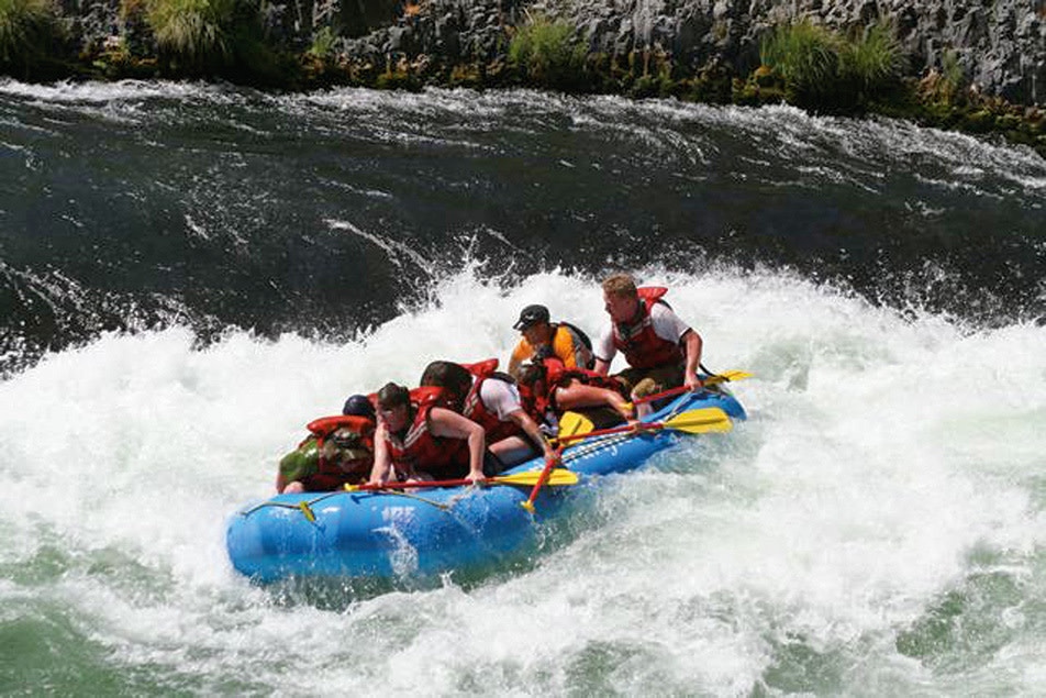
Riding the Deschutes on a guided trip with River Drifters.
Image: Shawn Miles
DISNEYLAND
Deschutes
FORGET SPACE MOUNTAIN; the Deschutes River boasts 252 miles of endorphin-inducing adventure (and no mildly disturbing man-size mice). With a litany of paddling, fishing, and hiking options, the river—one of the most rafted in Oregon—is about as close as you can come to an outdoor amusement park without actually paying for admission. Its quality white water and reliably hot desert temperatures mean that the river teems with rafts all summer long, while its legendary spring salmonfly hatch draws fishermen from across the country. And it’s little wonder why: rising just east of the Three Sisters Wilderness, the river rumbles over ponderosa-studded flats toward Sunriver, then weaves through islands and ramparts of hard black rock from six-thousand-year-old lava flows. Only the most skilled boaters attempt to plumb the falls created by these natural dams, but between the cataracts are placid sections lined by luxurious meadows—the result of silt dropped into the slow water above the falls. The real ride, though, comes just below Warm Springs, where for fifty-three miles, the free-flowing river carves its way toward the Columbia River through a rugged, nine-hundred-foot-deep desert canyon full of sagebrush, plentiful beaches, and rollicking white water. Now that’s our idea of a magic kingdom.
HIKE/BIKE An easy introduction to mountain biking in Central Oregon, the Deschutes River Trail traces the river’s west bank for fifteen miles—from downtown Bend, through a lunar landscape of jagged lava flows, and finally to Sunriver. You’ll share the trail with hikers, but the only real traffic jam comes at Benham Falls, where the half-mile-long stair-step cascade will remind you of how the Deschutes (French for “of falls”) got its name. If you don’t have your own ride, Hutch’s Bicycles in Bend rents mountain bikes for the day (hutchsbicycles.com; $30). Way, way downstream, the Lower Deschutes River Trail—an abandoned railroad grade converted into a moderate fat-tire route (see “Railroad Wars”)—follows the river for eighteen miles, from the Deschutes River State Scenic Area (oregonstateparks.org) to the flat water behind the Dalles Dam, where it quietly merges with the Columbia.
PADDLE Sun Country Raft Tours’ Raft and Brew trip (suncountrytours.com; $57) tackles the short but splashy Big Eddy section, where much of the 1980s frat-house comedy Up the Creek was filmed. Once the rush of the Class III white water wears off, you’ll experience a different kind of buzz from a tour of Cascade Lakes Brewing Company’s beer-making facility, which ends with a sampling of six different brews. Sun Country also runs daylong tours ($106) on the very popular Maupin segment downstream of Bend, a thirteen-mile run rife with Class II and III rapids, like the stomach-dropping Surf City and Oak Springs, where the frothy water regularly soaks river riders. Those in the mood for more solitude and a little desert stargazing might opt for Ouzel Outfitters’ three-day trip on the roadless Wild and Scenic section of the Deschutes, upstream between Warm Springs and Sherars Falls (oregonrafting.com; $535).
FISH To beat the crowds during the fall steelhead run, some enterprising fishermen traverse the Lower Deschutes River Trail on bicycles to head off the big fish as they wiggle upstream from the ocean to spawn. If you’re not completely comfortable in your waders yet, try a guided day trip with Deschutes Angler, which specializes in instruction in the two-handed Spey casting technique for steelhead (deschutesangler.com; $560). Or for a more luxurious experience, book the fully catered, three-day-long float trip on the twenty-five-mile section of the river below Sherars Falls ($2,745 for one or two people).
Spending some quality time on the Metolius River.
Image: Andy Anderson
THE INVINCIBLE
Metolius
THIS TWENTY-NINE-MILE-LONG RIVER apparently has a target on its back. Cascade lava flows have tried to squelch it no fewer than six times in the past five million or so years, including one particularly nasty attempt by Black Butte about a million years ago, when the volcano belched its fiery contents smack-dab into the riverbed. But the little river that could has always found a new path. Today, the Metolius wells up from beneath the bristled cone of Black Butte—at eighty feet wide, a river born almost whole—then races northward at nearly nine-hundred-thousand gallons a minute toward Lake Billy Chinook, where it makes a final wide turn into the Deschutes River. Despite its geological mystique, the Metolius is no mystery to fishermen, who flock to its banks in the summer to cast for brown trout and redband rainbows. Fittingly, given the river’s own hard-won survival, every inch of this serpentine stream is reserved for catch-and-release fishing.
FISH Historically, sockeye salmon have had a large run on the Metolius, but today, trout are king: brown, rainbow, redband, even the endangered bull trout all call the river home. When it comes to landing them, though, you’re more or less on your own. Because of a treaty with the Warm Springs Tribe—which owns the west bank of the lower river—the Forest Service has prohibited commercial guided fishing excursions on the Metolius. So stop into the Camp Sherman Store (campshermanstore.com), a full-service fly shop (see “Base Camp”), to find out what flies the fish have been taking.
HIKE While a handful of paddlers brave the Metolius’s cold, clear waters (the river flows at 48 degrees year-round), the paths surrounding the river are more popular, and they’re known as a haven from summertime heat. Old-growth ponderosa pines provide cooling shade on the six-mile West Metolius River Trail (www.fs.fed.us), which flits between forests and meadows. Bring a stash of quarters for your respite at the Wizard Falls Hatchery, about halfway up the trail, where you can buy fish food from the vending machines and play Santa to our finned friends in the open-air pools. For a tougher trek, take on the Metolius’s would-be murderer, Black Butte. It’s a quad-busting two-mile climb to the top of the 6,434-foot-high volcano, but the views of Mount Jefferson and the gnarled spire of Three Fingered Jack are to die for.

On the water in Oxbow Park.
Image: Megan Holmes
THE COMEBACK KID
Sandy
THE CLOSEST WILD AND SCENIC RIVER TO PORTLAND, the Sandy River is a better river now than it was two summers ago. Why? In the summer of 2007, the forty-seven-foot-tall Marmot Dam—the tallest concrete dam ever removed in the Northwest—was destroyed with 4,400 pounds of explosives to improve fish habitat and river recreation. While most environmentalists welcomed a newly restored section of free-flowing river, there was some controversy among biologists about whether the sediment that had accumulated behind the ninety-five-year-old dam would clog fish habitat downstream once it was removed. Happily, the silt washed downstream in months, rather than the years some scientists predicted, and boaters have been relishing the higher water levels ever since (more water means a longer river-running season, by a month or two). And with the removal of the smaller Little Sandy Dam in 2008, the Sandy is now completely unbridled. In fact, the river is one of only a handful of Oregon waterways whose entire lengths have been declared navigable—from its headwaters on Mount Hood’s Reid Glacier to its entry into the Columbia River just east of Portland. That means there are fifty-five miles of untamed river just waiting for Portland adventurers.
PADDLE If you want to elicit a Pavlovian response from paddlers, simply utter these three words: Sandy River Gorge. About thirty-five miles from the headwaters, the river cuts a serpentine path through layers of compacted volcanic ash; the deeply chiseled walls rise past vertical at times to become overhanging rock sculptures. Here, in the spring, snowmelt swells the river to levels high enough to slalom through rock-choked rapids like Rasp Rock and Boulder Rapid, where a waterfall plunges right into the white water, and boulders the size of houses clog the channel. If that sounds a little beyond your solo skills, fear not: River Drifters rafting company has your ticket to a guided ride (riverdrifters.net; $85). Below the gorge, the river eases into mellower water. The Class I section downstream of Oxbow Regional Park is particularly prized by canoeists, novice kayakers, and—in the hottest months—“redneck rafters,” who float on inner tubes towing essential supplies (i.e., coolers full of beer).
FISH Nowhere else in the country does a healthy steelhead stream flow through an area so heavily populated by humans. That’s in part because the loose gravel sliding down the river from Mount Hood makes for great spawning conditions for the large anadromous fish, which are more prevalent in the winter than in the summer. The fishing is good nearly everywhere along the Sandy’s fifty-five-mile passage (Oxbow Park has particularly easy bank access), but locals guard their favorite fishing spots jealously. Fortunately, the Fly Fishing Shop (flyfishusa.com) in Welches has been leading trips on the Sandy since 1981. In addition to their daylong float trip ($450), they also run half-day hike-in trips ($120) for the more budget conscious.
HIKE/BIKE Access to the Sandy’s most spectacular section—the seven-hundred-foot-deep canyon just below where Marmot Dam once stood—has been limited in the past, but in 2002 Portland General Electric began donating pieces of it to the Western Rivers Conservancy. Now, the Bureau of Land Management is creating about thirty miles of trails suitable for hikers and cyclists of all ability levels. The trails should be tread-ready in the next two to four years. In the meantime, get a close-up look at where the Comeback Kid meets the Columbia on the Sandy River Delta, where you’ll also find artist Maya Lin’s newly opened bird blind (see “Living History”). A network of dog-friendly paths crisscrosses the delta’s 1,400 acres, which boast cottonwoods, cherry trees, and a near-constant view of Mount Hood.
Living History
With the 2007 breaching of Marmot Dam, the lower Sandy River joined a growing number of Columbia Basin tributaries given freer flow in the hopes of restoring fish habitat. But the Sandy River is the only one with the distinction of being marked by an artwork: a bird blind completed in 2008. It’s one of seven landscape works designed by renowned artist and architect Maya Lin for her Confluence Project, a meditation on human impact on the Northwest landscape.

Image: Bob Meador
A 1.2-mile stroll from the Lewis & Clark State Park parking lot and mere steps away from where the Sandy originally intersected with the Columbia (before man-made levees diverted the flow about a mile west), Lin’s blind sits at about tree-bough height, at the end of a curving 150-foot ramp. The softly contoured ellipsis is made of wood slats harvested from the invasive black locust trees that spread across the Northwest. The slats are fitted together so closely, you can’t make out much more than the sensual shapes of the landscape outside. But the point is to train your eyes on the information inside, where Lin has deeply routed each slat with the name of one of the 134 birds, fish, and mammals that Lewis and Clark documented in their journals as they traveled through the area. In addition to the explorers’ often generic and eccentrically spelled labels, Lin has included the species’ official names, plus their current population status (unfortunately, this is “endangered” or “species of concern” in many cases).
Less about viewing birds than pondering how the coming and going of species impact one another, the blind recalls the subtle interplay of words and form in Lin’s other iconic works, namely the Vietnam Veterans Memorial in Washington, DC, and the Civil Rights Memorial in Montgomery, Alabama. This slice of art on the banks of the Sandy River is a quintessential Lin monument: rooted in a moment of history, but designed to reach centuries beyond it. —Randy Gragg