5 Urban Trails to Explore Near Portland
Canemah Bluff
Image: Courtesy James Schumacher
Writing Take a Walk: Portland, my compendium of 77 close-in nature walks (released in spring 2017 from Sasquatch Books), involved a jumble of numbers. More than 1,600 miles of driving. Three-hundred-plus miles of walking. A stack of Rite in the Rain notebooks, overflowing with smudge-proof ink. A three-pair rotation of shoes. After all that, I still can’t pick a favorite trail. Each greenspace, park, or natural area packed wonders, from swooping bald eagles to swarms of wildflowers to secret histories. Our collective backyard astounds. Here are a few recently opened or improved paths (some even too new to be included in the book). We’re betting you’ll love them all.
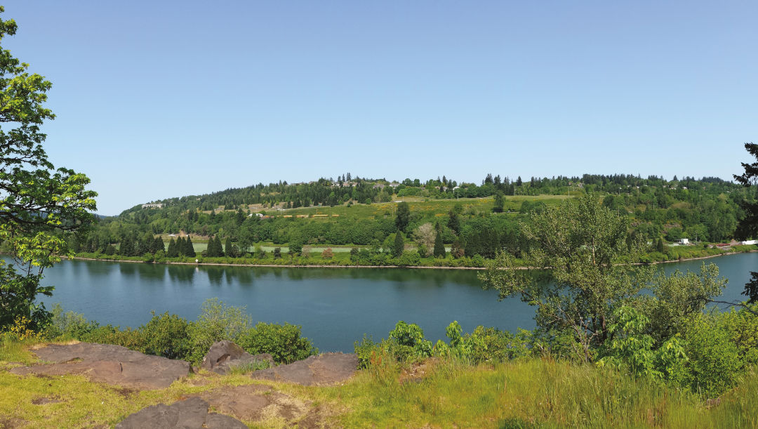
Canemah Bluff*
Canemah Bluff sits 0.5 miles upriver from Willamette Falls. Native tribes who gathered to fish at the falls used the oak- and fir-capped bluff as an encampment area. Old lanes also access the pioneer-era Canemah Cemetery. Yet in 2017, it’s Canemah’s newer features that get your attention. A new ADA-compliant crushed-gravel path leads through a restored prairie meadow to a lookout over the Willamette River and freshly signed trails. From the overlook, the trail enters a shady mix of firs and alders. Follow the road to the right toward jumbles of boulders tossed here during the cataclysmic Missoula Floods. To the left of the graveyard, follow a connection with the Licorice Fern Trail, which wends beneath a forested ridge line for 0.4 miles to a new trailhead. 815 Fourth Ave, Oregon City, 14 miles southeast of downtown Portland
Fernhill Wetlands*
This 700-acre wetland area near the Tualatin River has long been considered a jewel for birders—and things just keep getting better. A new path, opened in 2012, accesses a water garden designed by Hoichi Kurisu, a noted Oregon landscape architect who specializes in healing gardens. Throughout about 100 acres’ worth of ponds, 1 million native plants have taken root alongside 180 bird-attracting snags anchored into place. The main 1.1-mile loop is a wide-open gravel road that passes around a large treatment pond, with access to another smaller neighboring pond. Sticking to the main loop, pass along a dike leading to a large viewing gazebo where bald eagles are often spotted. 1399 SW Fern Hill Road, Forest Grove, 27 miles west of downtown
Scouters Mountain Nature Park*
Once the site of a Boy Scouts camp, Scouters Mountain near Happy Valley seems destined to continue nurturing love for the outdoors. The 932-foot-tall extinct lava dome is a natural site for exploration, with panoramic Cascade Range views and stands of centuries-old Douglas firs. After several years of restoration work, Metro opened the 100-acre site in 2014, with about a mile of trails. Clear days mean unrivaled views of Mount Hood and glimpses over the Columbia River. After circling the summit, trace the Boomer Trail down into a deep forest clinging to the mountainside. (The trail is named for an unusual species of mountain beaver that lives here.) As the trail continues through the mountain’s lush eastern flanks, scan the forest floor for mushrooms and herds of black-tailed deer silently loping among the trees. SE Boy Scout Lodge Road and 147th Avenue, Happy Valley, 15 miles southeast of downtown
Washougal Waterfront Trail
Completed in late fall 2016, the spiffy Washougal Waterfront Park provides gorgeous Columbia River sightseeing from the ease of a one-mile, wheelchair-accessible walkway. Frequent breaks in tree cover (along with gravel side paths to the water’s edge) provide chances to spot squadrons of Canada geese, great blue herons, and silhouettes of sails departing nearby Washougal Marina—all framed with eye-popping sightlines of Mount Hood. (A canoe and kayak launch makes nautical adventures easy.) Trail-goers in search of longer jaunts are in luck, too: both the Gibbons Creek Wildlife Art Trail and the Columbia River Dike Trail are just minutes from the park. 56 S First St, Washougal, Washington, 21 miles northeast of downtown
Orenco Woods Nature Park
This 42-acre park, a short walk from the Orenco Station MAX stop, officially opened in February 2017. Once home to the Oregon Nursery Company (famous in the early 1900s for its sweet Orenco apple), its remnant wetlands, oak savannas, and streamside forest now bulwark residential developments, providing refuge for beavers, black-tailed deer, red-tailed hawks, and songbirds. Tour rolling topography along the 0.9-mile Habitat Trail over pocket-size prairie and down to gurgling Rock Creek, a Tualatin River tributary holding cutthroat trout and lamprey. Then rise to meet the paved Rock Creek Trail (which links to nearby Orchard Park), where an arched bridge soars above creeks and wetland ponds. 7100 NE Birch St, Hillsboro, 15 miles west of downtown