8 Great Afternoon Hikes and Rides
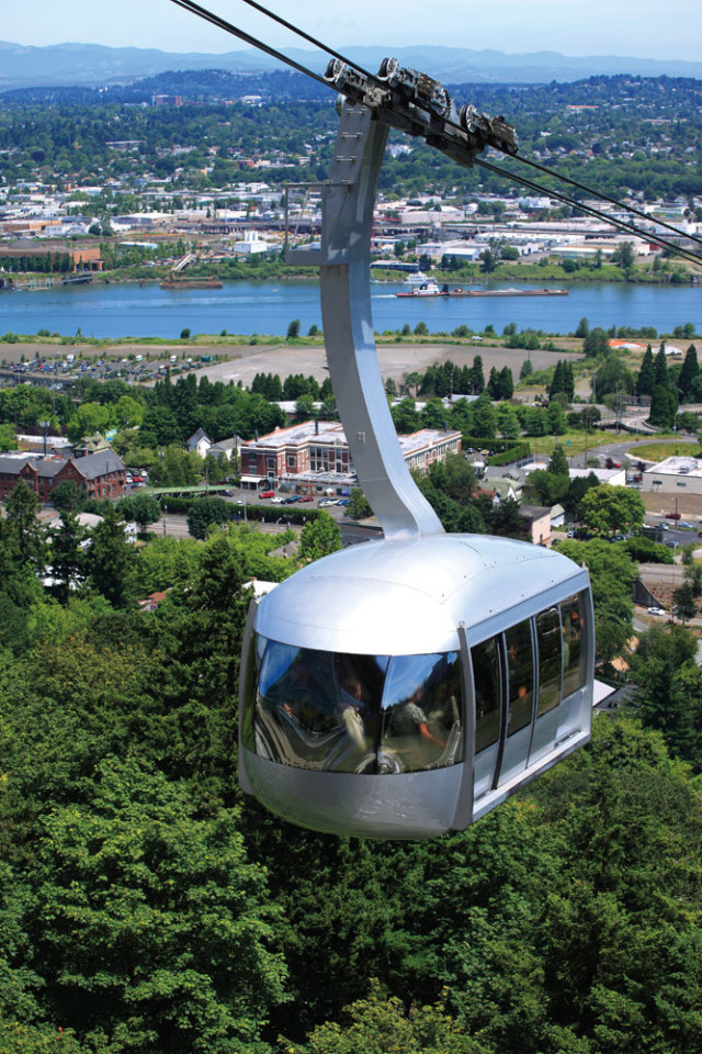
The Portland Aerial Tram
Image: Courtesy Shutterstock
HIKES
← The Urban Trek: 4T Trail
This city-meets-wilderness circuit got its name from the modes of travel you’ll use: MAX trains, hiking trails, trollies (a.k.a. the Portland Streetcar), and the Portland Aerial Tram. Start downtown by boarding the westbound MAX to Washington Park. Trail signs lead hikers over Highway 26 to a switchbacking climb up the rugged West Hills to Council Crest, the city’s mightiest summit at 1,073 feet. The five-volcano panorama is worth the trip alone. Next, descend through a thickly wooded ravine to Marquam Nature Park, and begin the climb to Oregon Health & Science University. Your reward? A scenic glide down the Portland Aerial Tram. Return via the Portland Streetcar. Access: Washington Park MAX station
Tryon Creek State Park
July temps inside Tryon Creek’s shade-drenched ravines seldom crack 80 degrees, making its 660 acres a go-to summer oasis. The showiest hike follows the Maple Ridge Trail down a gentle decline toward Middle Creek Trail and photo-ready High Bridge. Along the way enormous toadstools, old-growth cedar stumps, and late-blooming woodland flowers like clematis and false Solomon’s seal vie for attention. Don’t forget to scan tree trunks for owl nests and bat boxes—numerous barred owls and little brown bats inhabit the park. Access: 11321 SW Terwilliger Blvd
Firelane 15 Loop
Perched at Forest Park’s northern tip, Firelane 15 borders a power-line corridor that surveys Sauvie Island farmland and St. Helens’s snowy dome. To the west, a blanket of rugged blue hills unfurls to the Coast Range. Such remote topography is a solid bet for wildlife encounters. Park workers routinely spot coyote and black-tailed deer darting into the brush. And don’t miss the side trail from Firelane 15 to Keilhorn Meadow, a secluded, hemlock- and maple-fringed field—as pretty a place as any to listen for great horned owls. Directions: From NW Skyline Blvd, follow Firelane 15, cross over the Wildwood Trail, and turn right on Firelane 12 to BPA Road. Go right on BPA Road and turn right on Wildwood Trail. Return via Firelane 15.
Cooper Mountain Nature Park
Distinctive trailside features like a bird’s nest–themed iron sculpture, swiveling “listening posts” that zero in on melodic chatter, and a nature-scape playground make this Metro’s most engaging natural area. The hiking’s not bad, either. A web of gravel-strewn trails (all of which can be explored in a morning or afternoon) tours restored woodland habitats and oak savannas, delivering vistas of distant, vineyard-dotted hillsides. Keep an eye peeled for the resident bobcat, who’s routinely spotted prowling the open meadows for stray bird eggs and unwary gray squirrels. Access: 18892 SW Kemmer Rd, Beaverton
Lacamas Lake Park
The 312 acres here pack in conifer groves, fetching waterfalls, fir-ringed Round Lake, and, in spring, tiers of rocky meadows electrified by scores of camas lilies. Mountain bikers fawn over challenging patches of rooty singletrack and lung-burning chugs up dirt roads. Birders favor the adjoining Washougal River Greenway for a 2.6-mile tour of avian-rich wetlands. Need a skinny-tire cruise? The paved Lacamas Heritage Trail stretches 3.5 miles alongside Lacamas Lake, offering chance encounters with herons, double-crested cormorants, and bald eagles. Access: 3344 NE Everett St, Camas
BIKES

Image: Brian Barker
Tualatin Valley Scenic Bikeway →
One of the state’s newest scenic bikeways charts 50 miles of Willamette Valley splendor, linking Hillsboro’s Rood Bridge Park to rustic Vernonia. In between, a cinematic landscape unfolds: low-traffic blacktop roads wind among oak-dotted horse pastures, a pioneer cemetery, barns, and grain silos before joining the Banks-Vernonia State Trail, a 21-mile, car-free bikeway that bisects L. L. “Stub” Stewart State Park. Not up for the century-distance round trip? The bite-size (and relatively flat) 24-mile out-and-back tour between Hillsboro and Forest Grove comes loaded with excellent birding at Fernhill Wetlands and enticing pit stops like Unger’s Farm Store and Oak Knoll Winery. Access: 4000 SE Rood Bridge Rd, Hillsboro
EasyClimb Trail
Constructed by the Northwest Trail Alliance to build momentum for the larger, 25-mile CLIMB (Cascade Locks International Mountain Biking) trail network, EasyClimb is a forgiving beginner’s route. The trail provides stunning views of the Columbia River and the breathtaking walls of the river gorge. Though it climbs only 200 feet, the trail is relatively narrow, with twists and turns aplenty, making it a great spot for the novice mountain biker to build confidence. Access: Cramblett Way, Cascade Locks
Sandy Ridge Trail System
Designed by the International Mountain Biking Association (IMBA), the Sandy Ridge Trail System delivers 15 miles of world-class singletrack riding options just 40 minutes from Portland. Silky-smooth bermed corners and expertly contoured paths drop bikers past a menagerie of western red cedars, hemlocks, mossy Douglas firs, and rushing stream crossings. The trail flows so well that the state’s premier mountain biking competition, the Oregon Super D Series, selected Sandy Ridge for its summer circuit in 2010. Meanwhile, Laura’s Loop, a three-quarter-mile nontechnical ride, provides a ready training ground for newbies. Access: E Barlow Trail Road


