Where to Hike in the Columbia River Gorge
You can access this 64-acre eastern Gorge preserve, known as Dancing Rock, only on a hike led by Friends of the Columbia Gorge.
Editor’s Note: Originally published in June 2012, this article was updated in May 2017 for accuracy and relevance.
From hidden hikes to wildflower rambles, these are some of the Gorge’s best outdoor excursions, organized by distance from Portland. Want more options? Just type “Gorge” into our trail directory.
Less than 40 Miles from Portland:
Portland Women’s Forum State Scenic Viewpoint
Distance from Portland: 24 miles
Using funds from bake sales, tea sales, and fashion shows, a group of forward-thinking women snapped up this seven-acre parcel of land in 1956, recognizing that it held one of the grandest—and most accessible—perspectives of the Columbia River wending its way through fir-flecked slopes from arid eastern plateaus. Depending on how you frame your shot, you’ll also sneak Vista House and Beacon Rock into the scene.
Gibbons Creek
Distance from Portland: 25 miles
Opened eight summers ago, the treasures of the 2.25-mile Gibbons Creek Wildlife Art Trail outside Washougal remain a well-kept secret. Set in the 1,049-acre Steigerwald Lake National Wildlife Refuge, at the mouth of the Columbia Gorge Scenic Area, the shallow lakes, creeks, and groves of oaks and cottonwoods here are a scenic rest stop for nearly 200 species of migratory avian life, including purple martin and American bittern. Don’t just look up, though. Sunbathing western painted turtles and leaping blacktail deer are among the dozens of four-legged critters spotted here.
St. Cloud Trail
Distance from Portland: 36 miles
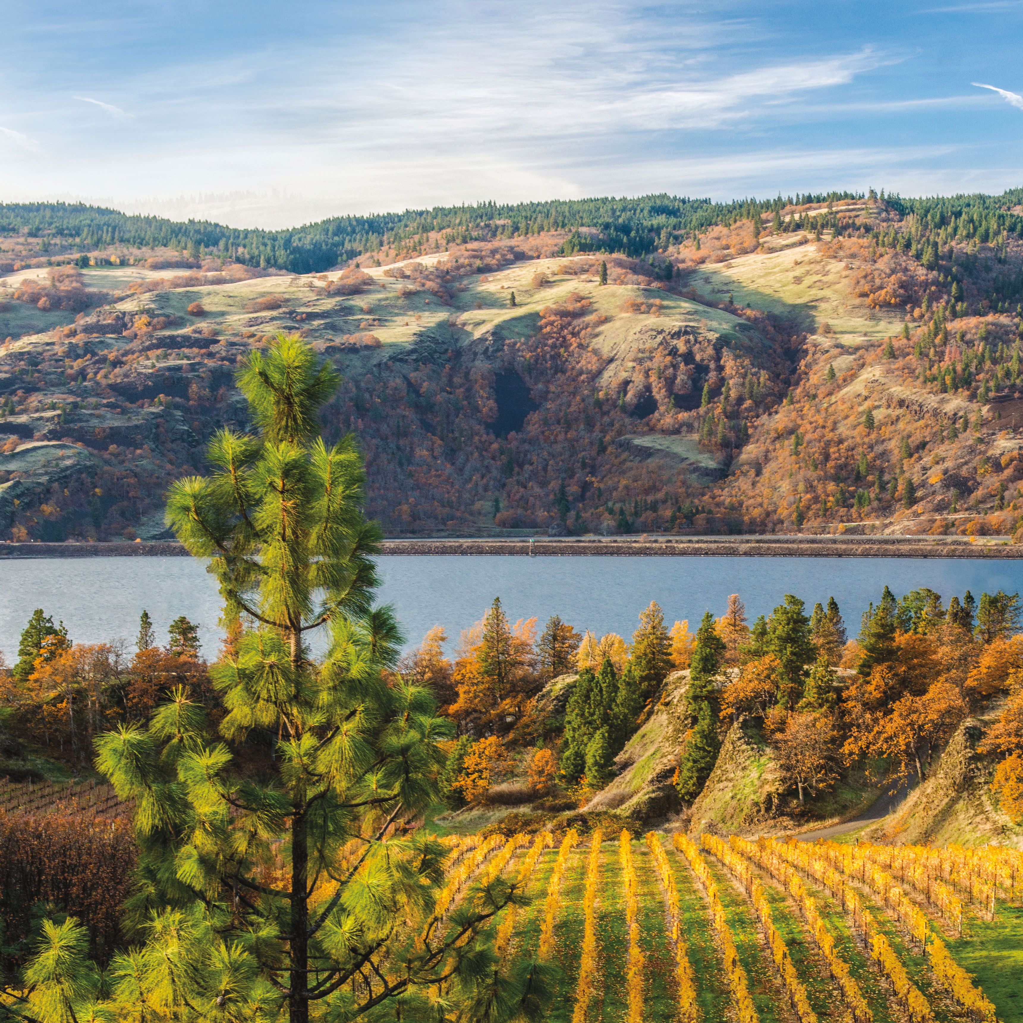
Often overlooked for more high-profile geologic settings on Highway 14, like Beacon Rock State Park (just five miles down the road), the St. Cloud Trail wanders through one of the most distinctive settings in the Gorge: an abandoned apple orchard hugging the banks of the Columbia River. At just a half-mile, the easy, kid-friendly loop can be finished in a blink. But with a scattering of picnic tables, a stretch of sandy beach, and a delightfully competition-free gaze at Multnomah Falls across the river, don’t be surprised if you wind up spending an entire afternoon on your own version of Cloud Nine.
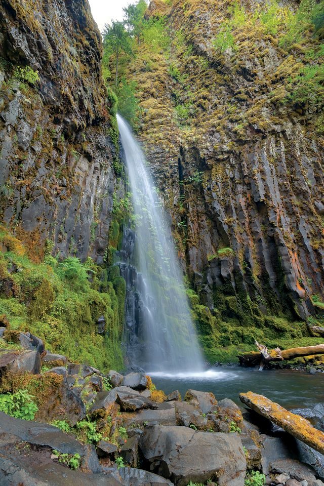
Elowah Falls
Distance from Portland: 36 miles
A few miles east of the Gorge's bumper-to-bumper waterfall circuit, Elowah Falls and Upper McCord Creek Falls provide a remarkably traffic- and crowd-free experience. After a trek in of about a mile, hikers face a choice: A left turn leads to a gentle, half-mile-long ascent to the base of Elowah*, a mighty 289-foot beast plummeting over a striated stone amphitheater. To the right, a steep series of switchbacks blasted into the cliff face delivers stunning views of Elowah and the Gorge all the way up to the twin falls of Upper McCord Creek. The best decision? Try ’em both. After all, you won’t have the hordes slowing you down. *At publication time, this trail section was closed due to landslide, with a scheduled reopening in June 2017.
Fairy Falls
Distance from Portland: 38 miles
A mere 150 yards off the Historic Columbia River Highway, Latourell Falls graces almost every Gorge visitor’s photo album. The real prize, though, is nearby Fairy Falls. A steep, one-mile climb shoos many shutterbugs away, but those who hoof (and huff) it up the grade are rewarded with a storybook cascade gracefully stair-stepping down stone against a verdant backdrop of ferns and trees.
40–60 Miles from Portland:
Dry Creek Falls
Dry Creek Falls
Distance from Portland: 44 miles
Every Portlander needs a hike like this stashed in the back pocket: close, just challenging enough to impress flatlander guests who crave a little Northwest adventure, with a cooling cascade as the payoff. Start from the Bridge of the Gods trailhead and head up the Pacific Crest Trail. After ducking under a highway overpass, ascend through light-dappled woods, following the PCT signage, about two miles. Instead of crossing the wooden footbridge that spans Dry Creek, bear right toward the falls: a vigorous, 74-foot spout surging out of an amphitheater of basalt walls, ringed by antique dam gear.
Hardy Ridge
Distance from Portland: 45 miles
Wedged between two popular Washington hiking spots—Beacon Rock and Hamilton Mountain—the challenging Hardy Ridge Trail doesn’t attract a ton of traffic. But those who tackle the seven-mile loop’s quad-busting climb through hemlock forest, along open meadows, and past bare rocky outcroppings walk away with plenty of Flickr fodder: glimpses of Mount Adams’s peak and Hamilton and Table Mountains abound, as do brightly tipped wildflowers like Indian paintbrush, and shrubby penstemon in full bloom from May through late July.
Table Mountain
Distance from Portland: 47 miles
Let’s just be clear: it’s going to kick your ass. Table Mountain’s soaring, jagged cliff face and spectacular views of the Columbia give it one of the Gorge’s biggest payoffs. The upfront investment required is something—more than 4,000 feet in elevation gain, a 15-plus-mile round trip. Along the way, however, you can cool your heels at Gillette Lake, an oasis encased in greenery, and Greenleaf Falls, while soaking up glimpses of Wauna Point and Kidney Lake. Several steep options reach the summit, and the whole Gorge opens beneath you.
More than 60 Miles from Portland:
The Hood River Spit
Distance from Portland: 63 miles
The Gorge’s hardy tribes of wind and water riders converge at this popular beach, where the Hood River Bridge provides a windbreak to keep your camera from rattling around (and your hat from ending up in the frame).
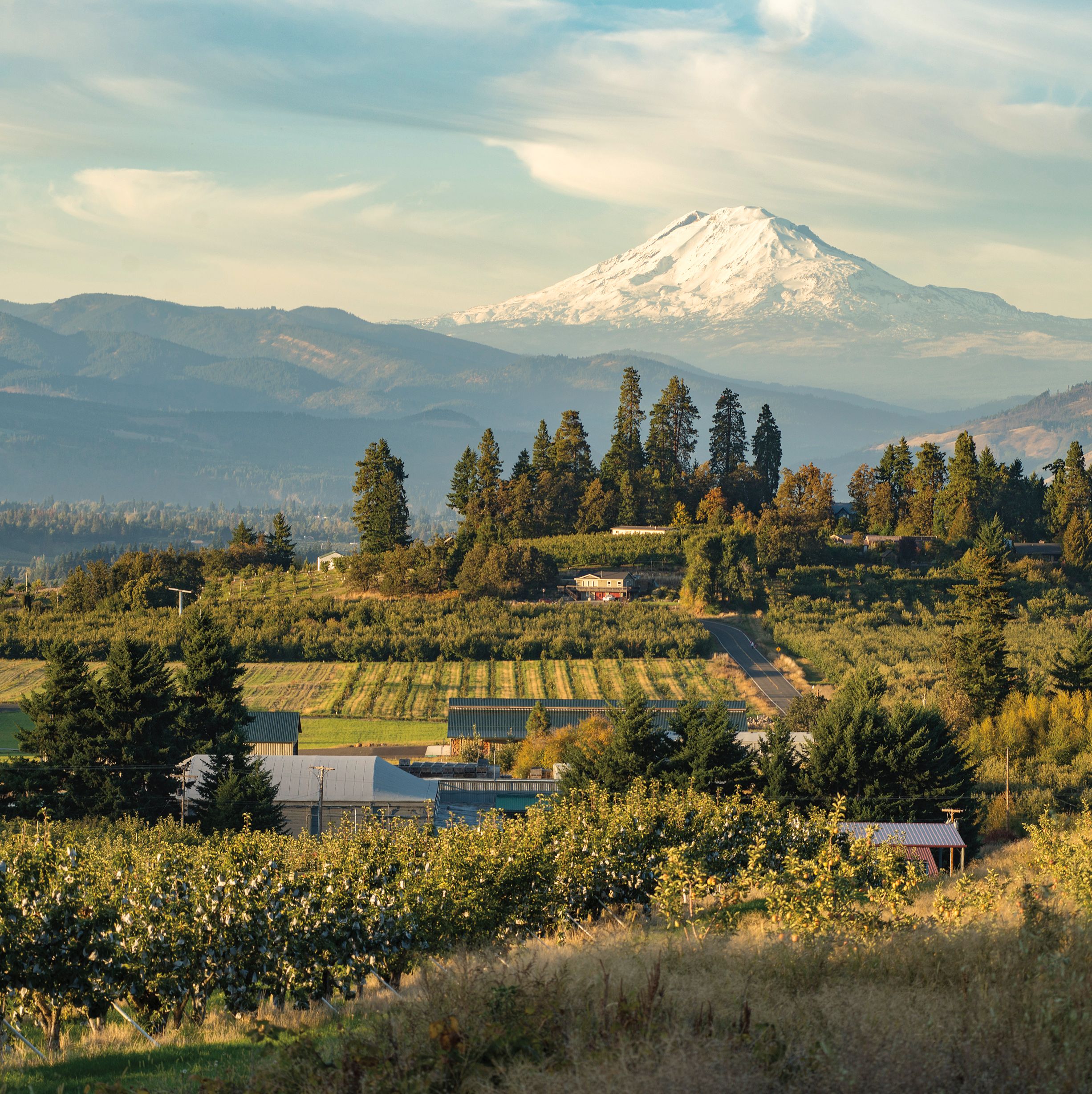
Panorama Point County Park
Distance from Portland: 65 miles
Mount Hood’s snowy triangle dominates the scene at this aptly named Highway 35 pullover, which surveys pride-swelling views of the Hood River Valley’s brightly hued orchards and farms as they stretch up to meet the green-blue forests skirting the majestic peak.
Mosier Plateau Trail
Distance from Portland: 69 miles
Officially opened in 2013, this scenic 3.5-mile ramble along sunbathed hillsides above Mosier is still too new to feature in many guidebooks. (Consider it a crowd-free alternative to well-trodden wildflower beacons like Dog Mountain or Rowena Crest.) Begin from the south side of the bridge in Mosier and wind past a small pioneer cemetery before reaching Mosier Creek Falls, a multitiered gem cascading through thin plunge pools. Continue up a series of steep switchbacks and stair steps to a wide overlook that commands hillsides adorned with wildflowers in the spring. In high summer, Mosier Creek provides an ideal dog-days swimming hole.
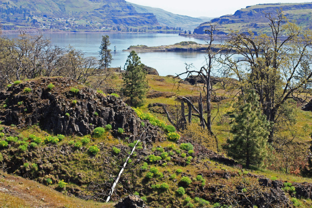
Catherine Creek on the Washington side of the Gorge looking at the Oregon side.
Image: Gary Windust / Flickr
Catherine Creek
Distance from Portland: 75 miles
More than 90 species of wildflowers bloom between February and July at this beloved Washington state park near Bingen, providing a photographic bonanza. The moderate and well-maintained trails also make carting equipment (tripods, for instance) a cinch. Photographers, pack your macro lens: that cluster lily is ready for its close-up.
Klickitat Rail Trail
Distance from Portland: 75 miles
All told, this abandoned rail line runs 31 miles between the Washington burgs of Lyle and Goldendale, including remote (and spectacular) sections closed during summer months due to fire danger. For a 13-mile gravel-grind even cycling newbies can take on (with the proper mountain or cross bike, of course), set up a return shuttle car in Lyle, then drive up to the trail access near Klickitat and head south. This section traces State Route 142 and the sometimes-raging Klickitat River; in winter, eagles often patrol above.
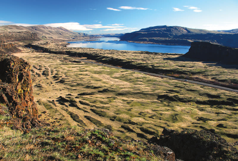
She Who Watches
Distance from Portland: 91 miles
Many of the carvings that reside at Washington’s Columbia Hills State Park, a few miles north of The Dalles, were jackhammered from nearby Petroglyph Canyon in the 1950s. Not She Who Watches, a mysterious petroglyph-pictograph who remains in her original place overlooking a stretch of river once called the Long Narrows. To ensure this massive petroglyph’s safety, the park limits access to twice-weekly guided tours in spring and summer. Tours from April through October on Friday and Saturday at 10 a.m. Reservations required: 509-439-9032.