16 Perfect Trails for Exploring Mount St. Helens
The West Side: 2 Hours from PDX

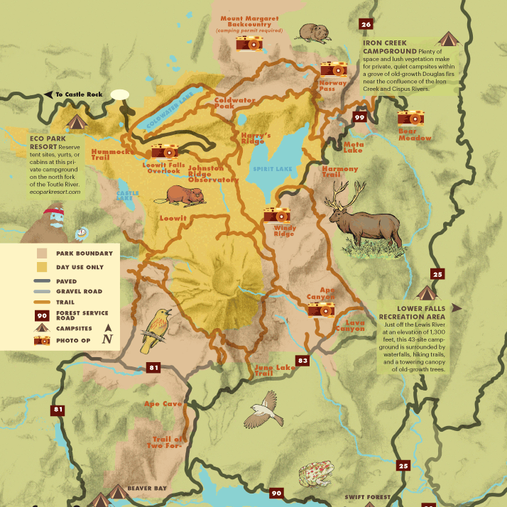
←Coldwater Lake
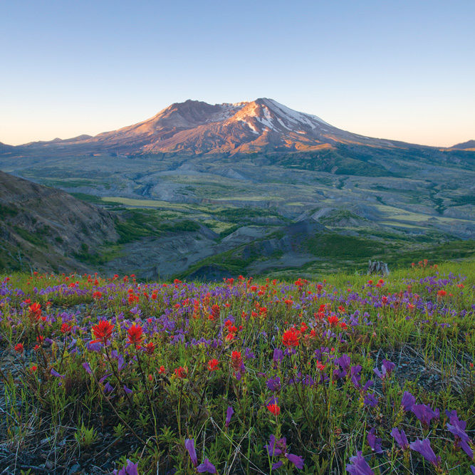
On the morning of May 18, 1980, Coldwater Lake was just a creek. By nightfall, the eruption’s record-breaking debris avalanche had dammed the creek, creating the 4-mile-long, 200-foot-deep lake that now sits in the northwestern shadow of St. Helens. The short Birth of the Lake Trail follows a boardwalk for an interpretive loop, while the Lakes Trail #211 skirts the flat northern shore for 4.5 miles. Kayaking outfits like Cascade Pack & Paddle allow you to venture beyond the majestic beauty of the wildflower-blanketed banks (home to many elk) into the lake’s center, where organic islands created by toppled trees speckle the surface and create a floating refuge for young plants and animals. Looking to make the most of your day? Follow up the 4- to 6-hour guided tour with a post-paddle wine tasting at Mount St. Helens Cellars.
Johnston Ridge Eruption Trail
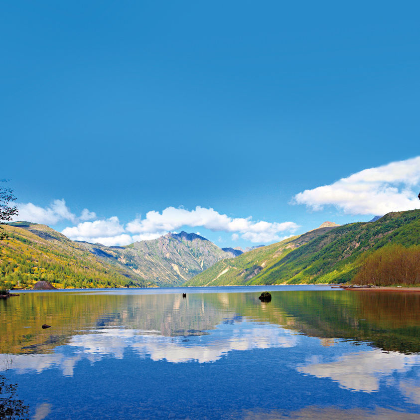
Mount St. Helens’s most popular walk also contains some of its most mind-blowing views. This short, paved hike is dotted with interpretive kiosks and stumps of blown-down tree as it skirts Johnston Ridge, which was shattered by a “stone wind” traveling 300 miles per hour in the 1980 eruption. Panoramic views across the pumice plain and into the volcano’s crater and lava dome reveal a lunar, contoured swath of burgeoning earth. Distance: .5 miles
Hummocks Trail #229
This family-friendly 2.5-mile loop is defined by a sequence of hummocks—essentially, huge chunks of the mountain’s former peak blasted sideways and deposited on the valley floor in the debris avalanche. The trail winds through this Badlands-esque landscape, flanks the Toutle River Canyon, then swings toward a cluster of wetland ponds, where the lovely canopy of an alder forest provides a welcome shady spot from which to spy on a huge beaver dam and lodge. Distance: 2.5 miles
Mount Margaret Backcountry
With its sapphire lakes, rugged, toothy peaks, and wildflower-blanketed slopes, the Mount Margaret wilderness area north of Mount St. Helens makes for a stunning backpacking getaway. Various loops lead hikers on otherworldly tours through the outer reaches of the blast zone, where blown-down trees and sun-baked pumice plains make for magical (albeit dusty) three- or four-day trips. This spring, the monument rolled out an online reservation system, making it easier than ever to obtain a permit ($6) for overnight camping at one of the area’s eight sites, reopened to the public in 1999.
Boundary Trail #1→
Views of Coldwater Peak to the north and the gaping crater to the south punctuate the gentle first two miles of this exposed hike through the blast zone. Then you’ll arrive at the aptly named Devil’s Elbow: a narrow ridge spine with a 600-foot drop below, and no handrail. If that doesn’t deter you, press on to the junction with the Truman Trail #201, and you’ll be treated to some of the best crater views and summer wildflower displays in the area.
Option #1: Harry’s Ridge—Keep left at the Truman Trail junction and follow the Boundary Trail for one more mile, where it connects with Harry’s Ridge Trail #1E, which rolls to the south atop the slope above Spirit Lake. Follow Harry’s Ridge to the right, and walk and gawk for a full mile at views of the storied lake below, where rafts of silvery logs still jam the placid surface. Distance: 8 miles
Option #2: Coldwater Peak—Keep left at the Truman Trail junction, follow the Boundary Trail for one more mile, and then stay left again at its junction with Harry’s Ridge Trail #1E. Soon, you’ll pass through a rock arch, zig west for a view of Mount Rainier, and zag east for a view of Mount Adams on your way to Coldwater Peak, where you’ll discover the best lateral view of the entire blast zone, along with a peek of Mount Margaret Backcountry to the north. Distance: 12 miles
Option #3: Windy Ridge—Keep right at the junction and follow the Truman Trail south toward the crater, where it loops around under Spirit Lake and winds north toward Windy Ridge. Distance: 14 miles
The East Side: 3 Hours from PDX
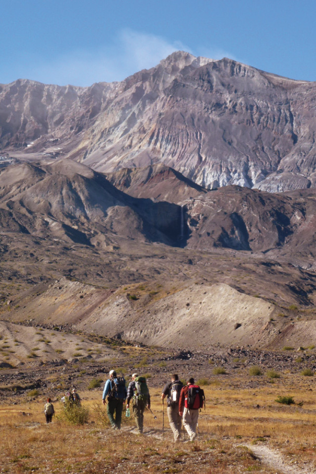
Inside the Crater→
There’s only one way into that gaping maw of a crater: a guided hike. Fortunately, Mount St. Helens Insitute offers a slew of expert-led climbs and seminars all summer, pairing geology and biology lessons with well-earned vistas. The Craterview Climbs gain about 1,200 feet over 8 miles, doling out eye-level views of the crater glacier and the lava domes along the way. The Into the Crater Hikes are a bit more taxing: 2,000 feet of elevation gain over 12 miles, half of it off-trail. But for a point-blank perspective on the origin of the blast zone, plus close encounters with Loowit and Step Creek Falls, it’s worth the sweat. Both excursions begin with a night at the institute’s Ridge Camp on Windy Ridge, where canvas wall tents and campfires make a welcome first step of the journey.
Meta Lake Trail #210
When St. Helens erupted in 1980, eight feet of snow sat atop the shores of frozen Meta Lake, which miraculously preserved the area’s understory of young silver firs and mountain hemlocks, not to mention the lake’s entire ecosystem. Today, this is one of the biological gems of the area, teeming with flora and fauna. A broad, paved trail weaves through the lush forest (and past the rusted remains of a Pontiac caught in the blast) to the lakeshore, cutting through meadows of thick grass. Distance: .5 miles
Norway Pass Trail
One of the more popular summer hikes in the area, this out-and-back jaunt into the eastern fringe of the blast zone contains the best perspectives of the area’s matchstick-like blown-down forest. The trail’s namesake terminus looks straight down the length of ghostly Spirit Lake. From the beginning, the scenery is staggering, from the ash-laden landscape studded with determined flowers and shrubs to the exposed trail tracing a windy ridge, complete with views of Rainier, Adams, and Hood. Distance: 4.5 miles
Harmony Trail #224
Though short, this rewarding trail is no walk in the park: over a single mile, you’ll descend 600 feet to the shores of Spirit Lake. It’s the only way to access the lake, and clearly displays one of the more dramatic effects of the eruption. When the 1980 debris avalanche slammed into Spirit, it caused a “tidal” wave: the water in the lake basin was pushed 800 feet up the hillside, ripping out mature trees as it sloshed over the ridgeline. From the shore, you can still see the scouring line on the hillside—along with a surreal view up into the crater. Distance: 2 miles
Windy Ridge
At about 4,000 feet, Windy Ridge is just about as close to the crater as you can get without climbing St. Helens, happily absorbing 360-degree views of all the icons of the area: Mounts Adams, Rainier, and Margaret, Spirit Lake, Johnston Ridge, the pumice plain, and more. But such rewards lie at the top of the Sand Ladder, a steep, zigzagging set of more than 400 timber steps climbing a sandy, lupine-studded slope to the ridgeline.
The South Side: 1 hour, 45 Minutes from PDX
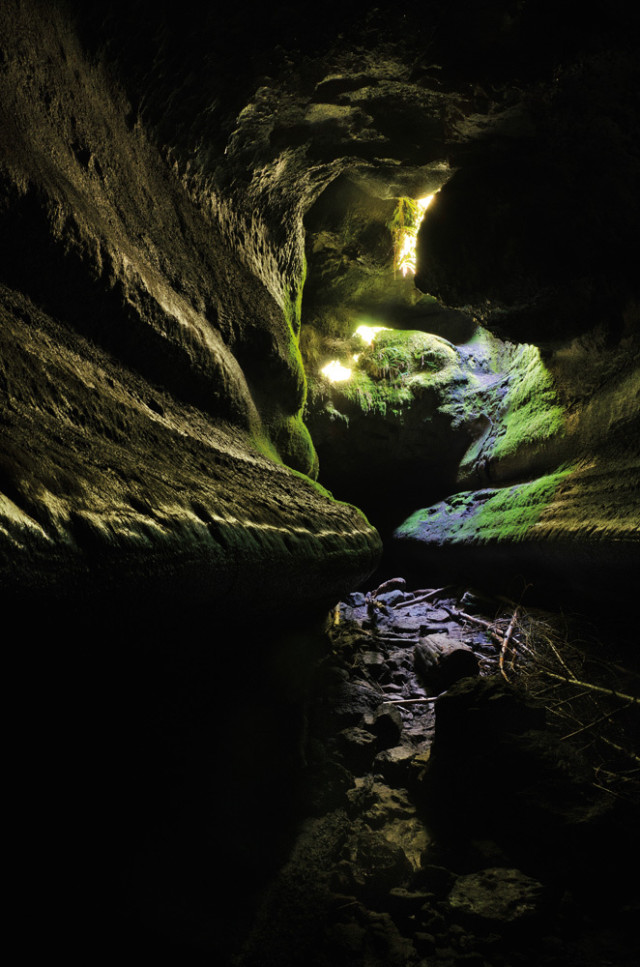
←Ape Cave
Entering the first chamber of Ape Cave feels like walking into the belly of a great subterranean beast: basalt walls ripple like ribs, smooth and shiny. The second-longest lava tube in the United States (2 miles long) formed nearly 2,000 years ago, when an eruption sent a river of molten rock flowing down St. Helens’s southern flank. As the surface cooled, it formed a thick crust, insulating the burning artery streaming beneath. Finally, hot volcanic gases followed the lava, glazing the undulating walls of the cave to give it its blue-black shine. Separate routes offer a three-quarter-mile, family-friendly option and a more adventurous 1.5-mile option, which requires one to climb 27 house-size boulder piles and scale an 8-foot lava fall. Expect temps around 42 degrees in the pitch-black tube—so you’ll need warm clothes, sturdy shoes, and two sources of light.
Trail of Two Forests
More stroll than hike, this whimsical boardwalk loop winds through two forests: one populated by old-growth Douglas fir, and one that was engulfed by the same ancient molten flow that formed Ape Cave. As the lava cooled around this forest’s standing and fallen trees, it entombed their massive trunks in stone. Fire then eviscerated the trees themselves, leaving “lava casts” that you can descend into via a ladder and crawl through. Distance: .5 mile
Lava Canyon Trail #184
This trail explores the area where the 1980 eruption sent a lahar down the south side of the mountain—a river of concrete rushed through the canyon and scoured its floor, exposing a stunning ancient lava flow beneath the forest. Options abound: walk the half-mile paved path to a waterfall viewpoint; continue on a 1.4-mile loop over two bridges, winding along the exposed cliff faces; or go even farther, descending 800 feet into the canyon for the views of the mud-scoured walls above. Distance: .5–6.5 miles
Ape Canyon Trail #234
One of the only trails open to mountain bikers on the south side of St. Helens, Ape Canyon is a 5.5-mile route that gains 1,300 feet as it skirts the edge of a mudflow and meanders through an old-growth stand of noble firs to emerge on the fringe of the blast zone. An open ridge hugging the volcano’s eastern flank affords dramatic views into Ape Canyon and Mount Adams in the distance. The trail officially ends at its junction with the Loowit Trail, which ambitious hikers can follow for 4 more miles to Windy Ridge. Distance: 11 miles
June Lake Trail #216B
An idyllic spot for a family picnic, June Lake lies at the end of an easy 1.5-mile, forested ramble. The picturesque, moss-walled alpine lake sits at the toe of a 1,600-year-old lava flow, nestled at the base of an andesite cliff over which a waterfall tumbles. Soak up the sun and the spectacular views on the ash beach, or connect to the Loowit Trail (below) and trek toward either the Climber’s Bivouac or Ape Canyon. Distance: 3 miles
Loowit Trail #216
The 28-mile Loowit Trail is the single route that circumnavigates the entirety of Mount St. Helens, and is breathtaking for its sheer diversity of terrain. The three-day trek leads ambitious backpackers on a journey through the whole St. Helens story. But be warned: water is sparse, sunshine is plentiful, and erosion on the trail makes for some harrowing detours. Access: June Lake trailhead